105.白石城 その3

旧城下町のエリアにも、白石城に関する見どころがいくつもあります。まず挙げられるのは、城の北側の三の丸にある武家屋敷です。この武家屋敷は、1730年に建てられたことが確認されています。

特徴、見どころ

天守内部

天守の中へは、本丸の内側から覆屋におおわれた石段を登って入っていきます。実はこの石段は、本丸御殿の「御成御殿」と同じように、藩主の伊達の殿様専用でした。他の藩士は天守のとなりの附櫓(つけやぐら)にあった通用口から出入りしていました。

本丸内側から見た天守
天守模型の入口にも覆屋が付けられています
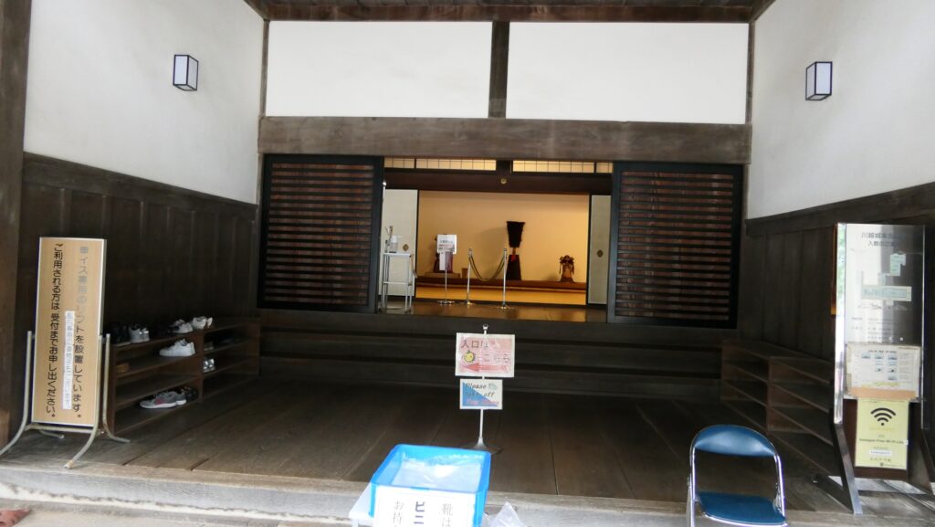
天守入口の石段

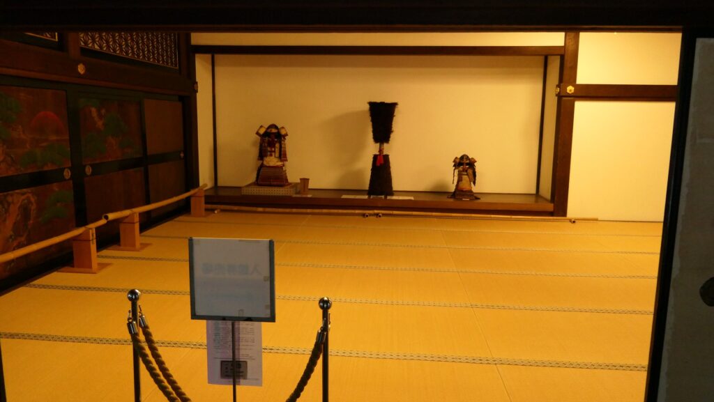
天守は三階建てで、全て木材による伝統的工法で復元されました。柱は吉野檜で、約250年持つということです。一階のレイアウトは発掘によって明らかになり、中央部分が武具の保管庫、その周りが武者走りとなっています。武者走りと壁沿いには、石落とし、狭間、格子窓などの防御システムが備えられています。

天守一階
中央には鎧兜が展示されています
格子窓(左)と石落とし(右)
狭間

上層階への階段はとても急ですが、オリジナルよりは緩やかで、補助の手すりも付いています。二階と三階のレイアウトは資料がなくて不明であるため、想定復元されていますが、オーソドックスな作りになっています。最上階(三階)は物見台になっていて、恐らくそれが正しいでしょう。現在ではビジターにとって快適な展望台となっています。

急な階段(二階部分)
最上階
最上階からの眺め
本丸と市街地の眺め

城下町の見どころ

旧城下町のエリアにも、白石城に関する見どころがいくつもあります。まず挙げられるのは、城の北側の三の丸にある武家屋敷です。この武家屋敷は、1730年に建てられたことが確認されています。片倉氏の配下で、中級クラスの武士であった小関氏が長い間住んでいました。その子孫の方も1991年まで住んだ後、白石市に寄贈したのです。市は住居をかつてあった状態に復元し、翌年一般公開しました。

旧小関屋敷

市街地周辺の航空写真

茅葺屋根の小さく簡素な屋敷で、部屋が4つあります(板間の茶の間と納戸、土間の台所、畳間の座敷)。建物が小さいのは恐らく、白石の藩士が伊達家に直接使える藩士に比べて比較的収入が少なかったからと思われます(小関家の場合は石高換算で15.5石、伊達家で中級とされたのは少なくとも30石以上だったようです)。それでも、沢端川が屋敷の2面を流れていて(屋敷の角で曲がっています)とてもよい立地です。

茶の間(居間)
座敷(現場では「なかま」と呼ばれています)
屋敷にある庭
沢端川が隣接しています

それ以外には、街の中を水路沿いに歩いてみたり、當信寺(とうしんじ)や延命寺(えんめいじ)では移築された城門を見学することができます。

當信寺にある旧東口門
延命寺にある旧厩口門(修繕中)

私の感想

振り返ってみると、白石城は2度の例外適用によって生き残ってきたことになります。一度目は江戸時代に幕府によって発布された一国一城令のときです。二度目は現代の権鞠基準法に関するものです。それに加えて、片倉氏や現在の白石の人たちの大いなる貢献がなければ、城の天守を目にすることはなかったと思うのです。

復元された天守

ここに行くには

車で行く場合:東北自動車道の白石ICから約10分かかります。
城がある丘の東側に「城下広場」があり、駐車場として使用できます。
公共交通機関を使う場合は、JR白石駅から15分程度歩くか、東北新幹線の白石蔵王駅からタクシーで約5分かかります。
東京から白石駅まで:東北新幹線に乗って、福島駅で東北本線に乗り換えてください。

白石駅

リンク、参考情報

白石城 公式ホームページ
・「日本の城改訂版第50号」デアゴスティーニジャパン
・「よみがえる日本の城17」学研
・「よみがえる白石城」碧水社
・「仙台藩の武士身分に関する基礎的研究」堀田幸義(宮城教育大学)の論文

これで終わります。ありがとうございました。
「白石城その1」に戻ります。
「白石城その2」に戻ります。

114.Karasawayama Castle Part3

The stone walls of the main enclosure entrance are not so high, but use several huge ornament stones.
In addition, the entrance was recently researched and it was found that it had a turret gate. Overall, these structures made the castle stronger as well as more authorized.

Features

Great Stone Walls of Main Enclosure

The stone walls are around 8m high and about 40m long. They were built by piling natural or roughly processed stones in a way called Nozura-zumi. They look rough but really great! It was said that the last lord, Nobuyoshi Sano built them by inviting an excellent guild of stone craftsmen celled Ano-shu from western Japan.

The map around the castle

The high stone walls of the enclosure
The stone walls seen from the second enclosure side

You will eventually enter the second enclosure just below the main enclosure. Therefore, you will see the entrance of the main enclosure, which was also surrounded by great stone walls. They are not so high (at 2.5m), but use several huge ornament stones, called Kagami-ishi (meaning mirror stones).
In addition, the entrance was recently researched and it was found that it had a turret gate. Overall, these structures made the castle stronger as well as more authorized.

The second enclosure in the front and the main enclosure in the back
The entrance of the main enclosure
One of the ornament stones

The enclosure is on top of the mountain and is used for the shine buildings. It is unknown what buildings it had in the past, but it might have had buildings like the Main Hall and the Main Tower.

The front shrine hall
The stone walls around the enclosure

Defensive Spots in North and South

There is another enclosure, in the south of the main enclosure, called Nanjo (meaning southern castle). It was built to protect the southern ridge of the mountain where you can see stone walls and dry moats around. The shrine office is on the enclosure and this is another great viewing spot. If the weather is fine, you can enjoy a view of both Tokyo Sky Tree and Mt. Fuji. Nobuyoshi might have had no choice but to accept the shogunate’s close questioning that looking down on Edo Castle from the mountain would be rude.

The southern castle
The stone walls around the enclosure
The dry moats around the enclosure, called the First Moat
A view from the enclosure, it was clouded when I visited there

There is also other enclosures on the northern ridges, such as the Northern Castle. They are basically made of soil, divided by earthen ditches and connected by earthen bridges, which were older parts of the castle.

The Nagato-maru Enclosure
The Kane-no-maru Enclosure
The Sugi Enclosure
The double ditches between the Sugi and northern enclosures
The northern enclosure

Hiking Course has other Castle Ruins

For hikers, it is recommended to try part of Karasawayama Shuyu(Round) Course, from the castle to Imori-yama Mountain via the Kagami-iwa Rock, Byobu-iwa Rock and Gongen-do Hall Ruins. The course is on another ridge connected to the Karasawayama Mountain, which was a defense point for the castle.

The map around the mountain

The relief map around the mountain

The location map of the hiking course
The Kagami-iwa Rock
The byobu-iwa Rock and the view

That’s why you can see a set of a narrow bridge with artificial ditches on the way. You can also enjoy a great view of the whole Kanto Region on each peak of the ridge. The Imori Mountain is where Kenshin Uesugi and Masatsuna Sano fought against each other in their last battle in 1570.

The bridge over the ditch
Going to the Gongendo Hall Ruins
A view from the hall ruins
The zoomed Mt. Fuji
The top of the Imori Mountain

Later History

After the Sano Clan was banished by the Tokugawa Shogunate, the Ii Clan which was a senior vassal family of the shogunate owned the Sano area as its detached territory during the Edo Period. The clan banned people from entering the mountain, the former castle area. That’s why the ruins of the castle have been preserved in a good condition. After the Meiji Restoration, locals established the Karasawayama Shrine in 1883. Establishing shrines on castle ruins was a popular way to maintain them at that time. The ruins also became part of Karasawayama Prefectural Natural Park in 1965. That’s why several approaches and hiking courses have been developed there. As for castle ruins, Sano City has been researching and studying them since 2007. As a result, they were designated as a National Historic Site in 2014.

Karasawayama Shrine

My Impression

The current people often say Kenshin Uesugi attacked Karasawayama Castle and approached its main enclosure, but failed. Meanwhile, Kenshin himself wrote on his letter in 1567 when he owned the castle and was attacked by the Hojo Clan that “Only the Main Enclosure remained”. I’m not sure if similar things happened twice whether the people misunderstood Kenshin’s sides. Either way, Kenshin and the castle were closely involved. I think the people are still borrowing his name even today to explain about the strength of the castle.

The main enclosure of Karasawayama Castle

How to get There

If you want to visit the castle ruins by car, it is about a 10-minute drive away from Sano-Tanuma IC on the Kitakanto Expressway.
There are parking lots at the foot, the mid slope and top of the mountain.
By public transportation, it takes about 40 minutes on foot from Tanuma Station on the Tobu-Sano Line to the top.
From Tokyo to the station: take the train on the Joban Line from Tokyo or Ueno Stations, transfer to the Tobu-Isesaki Line at Kitasenju Station, and transfer to the Tobu-Sano Line at Tatebayashi Station.

The parking lot at the top
The parking lot at the southern route
The parking lot at the western route
The parking lot on the way of the hiking course

That’s all. Thank you.
Back to “Karasawayama Castle Part1”
Back to “Karasawayama Castle Part2”

114.唐沢山城 その3

本丸虎口の石垣はそれ程高くないですが、鏡石が使われています。この虎口は最近調査されて、櫓門があったことが判明しました。これらの構造物は、城をより強力に、また権威を誇示する効果もあったことでしょう。

特徴、見どころ

本丸の素晴らしい高石垣

この石垣は約8mの高さで、長さは約40mもあります。野面積みという手法で、自然石か粗く加工された石を使って積まれています。粗野なように見えてその実、大変すばらしい出来です。最後の城主、佐野信吉が西日本から穴太衆という優れた石工の職人集団を招いて築かせたと言われています。

城周辺の地図

本丸の高石垣
二の丸側から見た高石垣

二の丸に入っていくと、そこは本丸のすぐ下になっています。よって、ここも素晴らしい石垣で囲まれた本丸虎口が見えます。この石垣はそれ程高くない(2.5m)のですが、いくつかの鏡石が使われています。この虎口は最近調査されて、櫓門があったことが判明しました。これらの虎口の構造物は、城をより強力に、また権威を誇示する効果もあったことでしょう。

二の丸(手前)と本丸(奥)
本丸虎口
虎口の鏡石

本丸は山頂にあって、現在は神社の建物があります。過去にどのような建物があったかはわかっていません。御殿や天守のような建物があったのかもしれません。

唐沢山神社
本丸周りの石垣

城の南北の防衛拠点

本丸の南側には「南城(なんじょう)」と呼ばれる曲輪があります。山の南側の峰を防衛するために築かれたもので、石垣や堀切によって囲まれています。現在、南城には社務所があって、ここも素晴らしいビューイングスポットになっています。天気がよければ、東京スカイツリーと富士山の両方を見渡すことができます。この山城から江戸城を見下ろすことが無礼だと、最後の城主、佐野信吉が幕府から詰問されたとしても、申し開きはできなかったでしょう。

南城
南城周りの石垣
南城周りの堀「一つ目堀」
南城からの景色、この日は曇っていました

山の北峰の方にも、北の丸などの曲輪群があります。これらの曲輪は基本土造りで、堀切によって区切られています。城の中では古い部分に当たります。

長門丸
金の丸
杉曲輪
杉曲輪、北の丸間の堀切
北の丸

ハイキングコースも城跡の一部

ハイキングをするのであれば、唐沢山周遊コースの一部となりますが、城の中心部から飯守山(いいもりやま)まで、鏡岩、屏風岩、権現堂を経由して歩いてみてはいかがでしょうか。このコースは、唐沢山につながるもう一つの峰の上を進むルートです。

唐沢山周辺の地図

唐沢山周辺の起伏地図

ハイキングコース案内図
鏡岩
屏風岩と景色

城にとっては防衛拠点の一つでした。そのため、峰上を歩く途中には、人工的な堀切の上を渡る橋があったりします。峰にいくつかあるそれぞれのピーク地点では、関東地方を見渡せるようなパノラマビューを楽しむことができます。飯守山は、1570年に上杉謙信と佐野昌綱が最後に戦った時の激戦地です。

堀切を渡る橋
権現堂(見晴小屋)へ
権現堂からの景色
富士山をズームアップ
飯守山山頂

その後

徳川幕府により佐野氏が追われた後は、幕府の重臣である井伊氏が佐野地域を飛び地として、江戸時代の間領有しました。その間、城であった山に民衆が立ち入ることを禁止していました。そのため、城の遺跡はよい状態で保存されてきました。明治維新後は地元の人たちによって、1883年に唐沢山神社が創建されました。当時は神社を設立することが、城跡を維持するための常套手段だったのです。城跡は1965年には唐沢山県立自然公園の一部ともなりました。これらの経緯により、いくつもの参道やハイキングコースが設定されています。城跡そのものとしては、佐野市が2007年以来調査研究を進めていて、その結果、2014年には国の史跡に指定されました。

唐沢山神社

私の感想

「上杉謙信が唐沢山城を攻撃し、本丸に迫ったが撃退された」というフレーズをよく聞きます。一方、謙信が唐沢山城を所有していたときに北条氏に攻められたことを記した、1567年の書状には「本丸のみが残っていた」とあります。攻守を変えて同じようなことが2度起こったのか、それとも現在の人が謙信が守っていたのを攻めた側と勘違いしているのか、よくわかりません。いずれであっても、謙信と唐沢山城が深い関係にあったのは事実でしょう。つまりは、現在の人たちは今でも謙信の名前を借りて、この城の強さを説明したいのだと思います。

唐沢山城本丸

ここに行くには

車で行く場合:北関東自動車道の佐野田沼ICから約10分かかります。山麓、中腹、山頂それぞれに駐車場があります。
公共交通機関を使う場合は、東武佐野線の田沼駅から頂上まで、歩いて約40分かかります。
東京から佐野駅まで:東京駅か上野駅から常磐線に乗って、北千住駅で東武伊勢崎線に乗り換え、館林駅で東武佐野線に乗り換えてください。

山頂の駐車場
南登山口の駐車場
西登山口の駐車場
ハイキングコース途中の第二駐車場

リンク、参考情報

唐沢山城の紹介、佐野市
・「日本の城改訂版第57号」デアゴスティーニジャパン
・「北条氏康の子供たち/黒田基樹、朝倉直美編」宮帯出版社
・「中世東国の政治と経済/佐藤博信編」岩田書院
・「関東の名城を歩く 北関東編/峰岸純夫・齋藤慎一編」吉川弘文館

これで終わります。ありがとうございました。
「唐沢山城その1」に戻ります。
「唐沢山城その2」に戻ります。