72.Yoshida-Koriyama Castle Part2

You can realize the Mori Clan’s long history by walking along the tour route.

Later History

After Yoshida-Koriyama Castle was abandoned, the Asano Clan managed to own its area during the Edo Period. This was because the Mori Clan’s territory had been reduced due to the their lost in the Battle of Sekigahara in 1600. The Asano Clan destroyed the stone walls of the castle after the Shimabara Rebellion in 1637. The Tokugawa Shogunate ordered the lords in western Japan to do it so that even abandoned castles would not be reused by other rebels.

The destroyed stone walls of the Third Enclosure

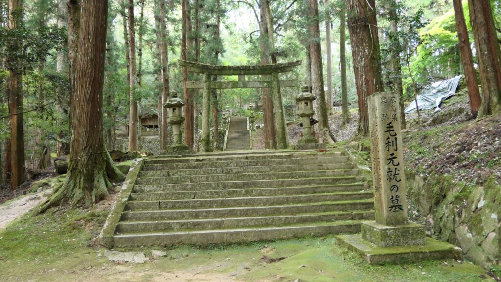
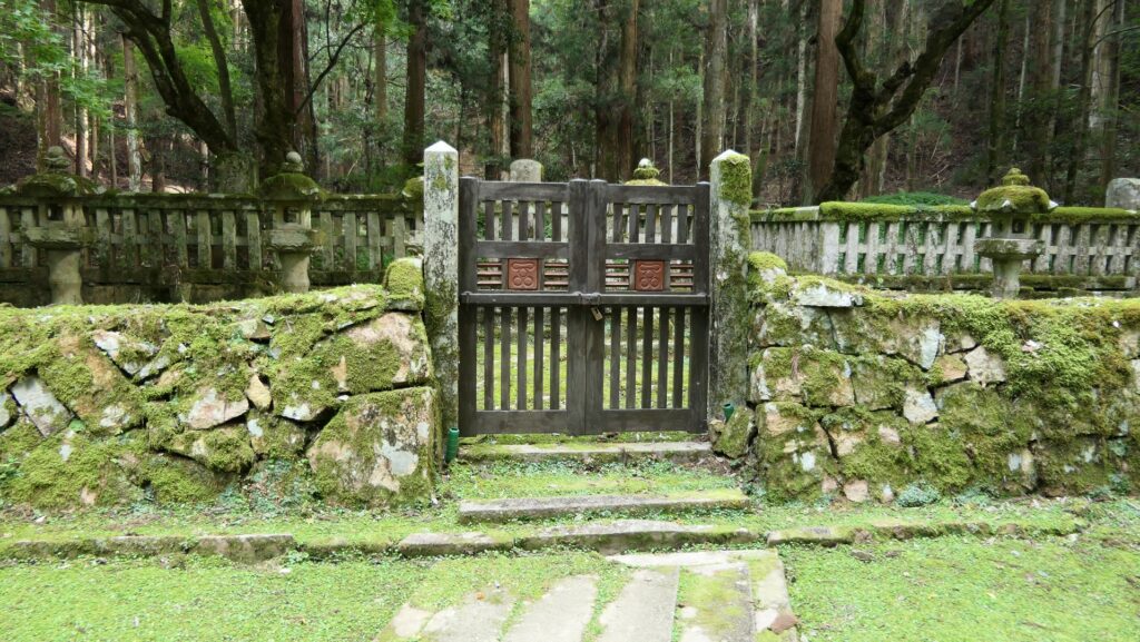
By contrast, the grave of Motonari Mori, which was built at part of the castle by his grandchild, Terumoto Mori, has been maintained. The Asano Clan allowed the lord and warriors of the Choshu Domain by the Mori Clan to pay a visit to the grave. As a result, warriors of other domains also visited it as the holy spot for a great warlord. After the Meiji Restoration, the grave was developed further, gathering the graves of other ancestors of the Mori Clan probably because the Choshu Domain was one of the victorious clans of the restoration. The castle ruins have been designated as a National Historic Site since 1940.

The grave of Motonari Mori in the castle

Features

Going to Entrance of Castle Ruins

Today, if you drive to the area around the ruins of Yoshida-Koriyama Castle, you will find some names of the local area like Katsura and Fukuhara. They are the origins of the Mori Clan’s senior vassals until the end of the Edo Period. History fans might be excited to just see them.

The map around Yoshida Town, Akitakada City

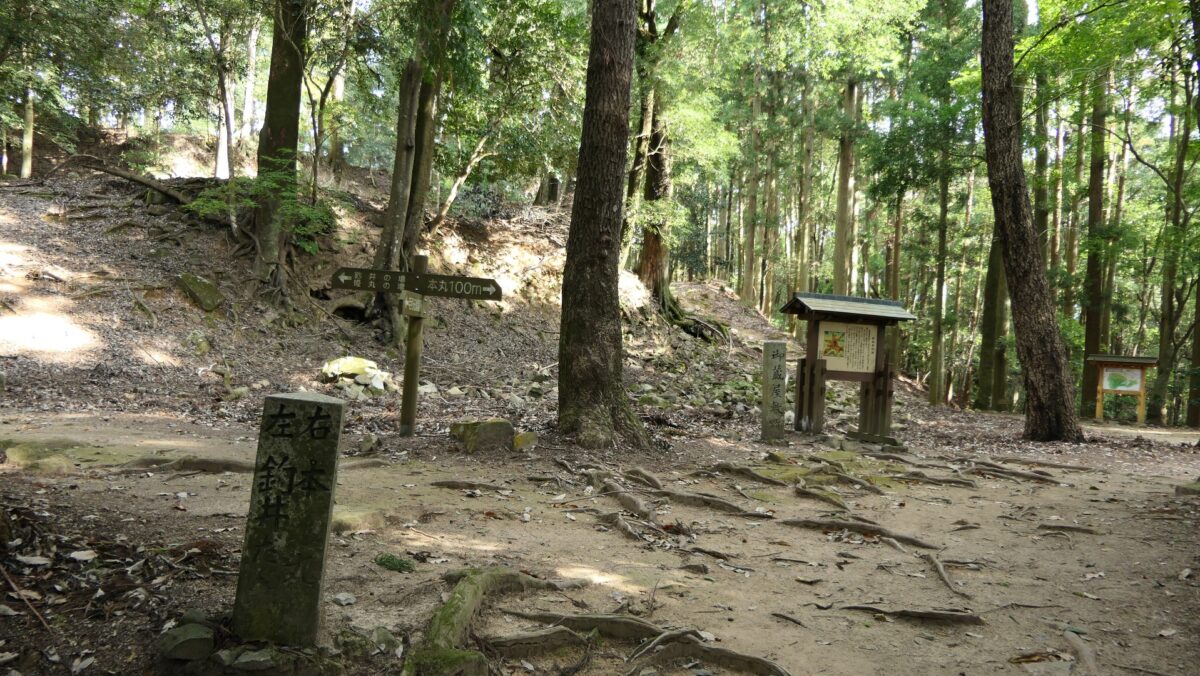
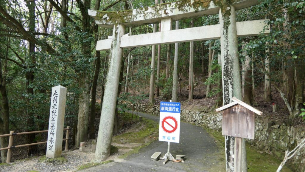
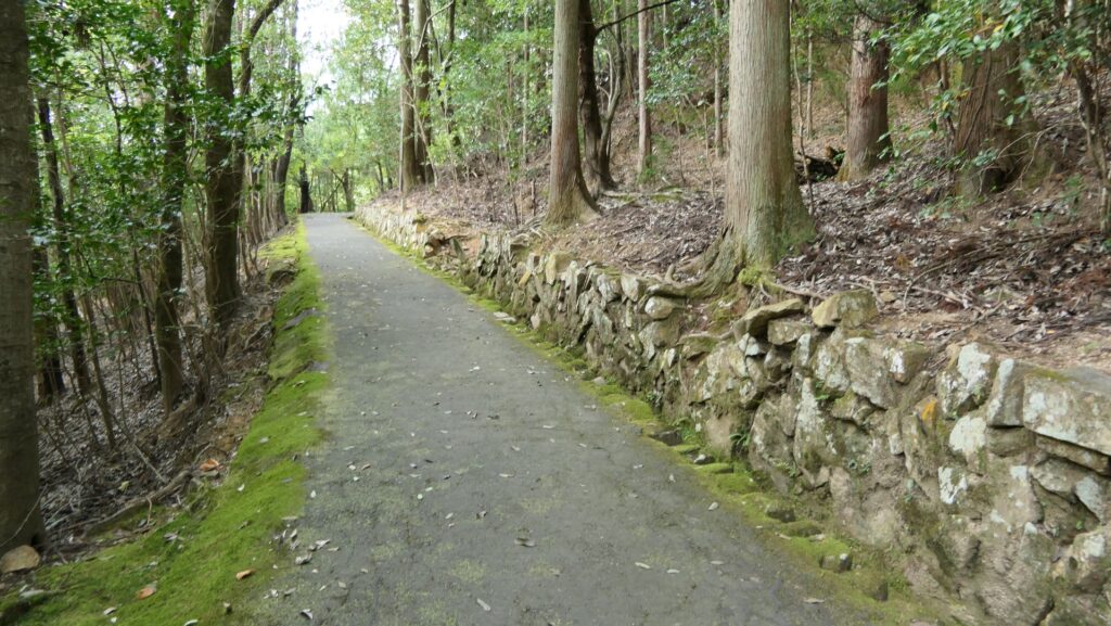
There is the tour route which is recommended by officials. Its starting point is the shrine gateway of Motonari’s grave, beside the parking lot at the foot of the mountain. If you walk along the approach towards the grave for a while, you will reach it. This may be the most developed place in the castle ruins as the holy spot. There is also Toshunji Temple Ruins which was established by Terumoto there and eventually moved to Hiroshima, Hagi and Yamaguchi with the lords of the Mori Clan.

The map around the castle

The shrine gateway of Motonari’s grave
The approach towards the grave
The grave of Motonari
Toshunji Temple Ruins

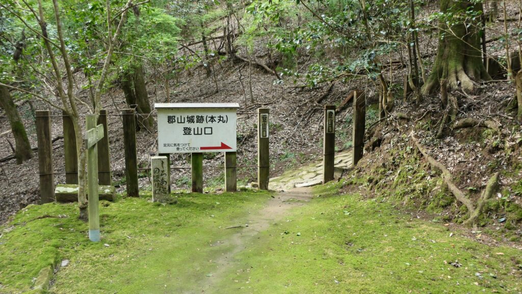
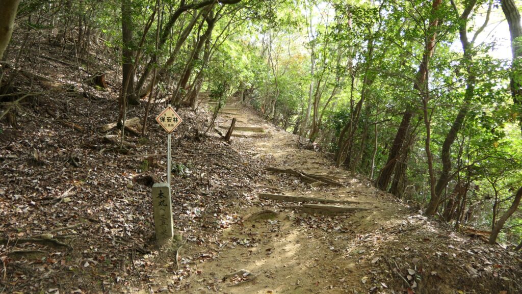
Trail on Ridge of Mountain

You can climb the trail to the top of the mountain from there, on one of its six ridges. It is basically a long trek which takes about 30 minutes to reach the top. You may find some ditches dividing the enclosures or wild animals like deer. Be careful not to provoke them.

The starting point of the trail
The trail goes on the ridge
A ditch dividing the enclosures
Meeting with a deer

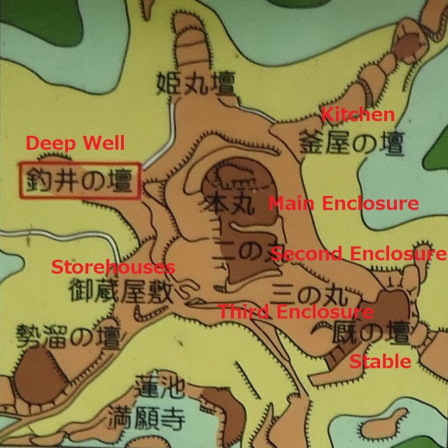
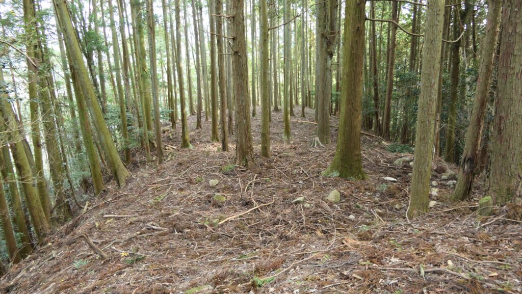
Enclosures on Top of Mountain

You will eventually arrive at the ruins of Okurayashiki or the Storehouses below the top. The top consists of three tiered enclosures of the Main, Second and Third. The six ridges spread from the top which also have so many enclosures.

The ruins of the Storehouses
The topographical map of the mountain top, from the signboard at the site, adding the red letters

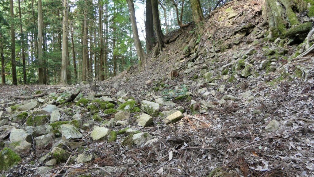
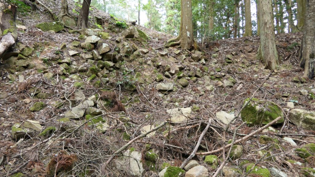
You will find countless stones collapsed which lie around the Storehouses Ruins. It is thought that this was caused by the Asano Clan following the shogunate’s instruction after the Shimabara Rebellion. These stones have been left there for nearly 400 years. However, if you walk around the wall of the Third Enclosure, you will notice some stone walls remaining as they were.

The collapsed stones lying around the Storehouses Ruins
Some remaining stone walls of the Third Enclosure

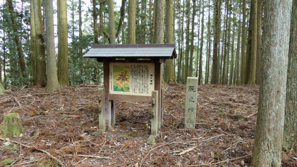
You can also walk around some enclosures on the six ridges such as Tsurii or the Deep Well, Umaya or the Stable, and Kamaya or the Kitchen. There will be a sign warning visitors not to enter that unstable area. Please make you don’t enter that area since it’s very unstable and could cause the land to collapse. Watch your steps as they are reclaiming to nature.

The Deep Well Enclosure
The Stable Enclosure
The ridge over the Stable Enclosure
The Kitchen Enclosure
Sone ridges are not allowed to enter as of October 2022

To be continued in “Yoshida-Koriyama Castle Part3”
Back to “Yoshida-Koriyama Castle Part1”

72.吉田郡山城 その2

城跡を巡ってみれば、毛利氏の長い歴史を実感できます。

その後

吉田郡山城が廃城となった後、浅野氏が江戸時代を通じて城があった地域を領有していました。1600年の関ヶ原の戦いの敗戦により、毛利氏の領地が大幅に削減されてしまったからです。浅野氏は、1637年に起こった島原の乱の後、城の石垣を破壊しました。徳川幕府が西日本の大名に対して、廃城となった城であっても反乱者に利用されないように命じたからです。

崩された三の丸の石垣

対照的に、孫の毛利輝元によって城の一部分に作られた毛利元就の墓所は、維持されていました。浅野氏は、毛利氏の長州藩の領主や藩士たちが元就の墓所に墓参りすることを許していました。結果的に、他の藩の藩士たちも偉大な戦国大名の聖地として同じように元就の墓所を訪れるようになりました。明治維新後、墓所は毛利氏の他の先祖たちの墓も集められ拡張されました。恐らく長州藩が、明治維新における勝者であったからできたことだろうと思われます。城跡は、1940年以来、国の史跡に指定されています。

城内にある毛利元就の墓所

特徴、見どころ

城跡入口へ

もし吉田郡山城跡周辺を車で回ってみると、この地には「桂」や「福原」などの地名が今でも残っていることに気付かれるかもしれません。これらの地名は、江戸時代末期まで毛利氏の重臣であった桂氏や福原氏などの出身地であることを示しています。歴史ファンの方はそれを見ただけでもわくわくするかもしれません。

安芸高田市吉田町周辺の地図

吉田郡山城跡を巡るには、推奨ルート(現地案内図に記載)が設定されています。そのスタート地点は、山麓にある駐車場傍の、元就の墓所の入口となる鳥居です。その鳥居から墓所向かう参道をしばらく歩いて行くと墓所に着きます。ここは城跡の中では聖地としてもっとも整備されている場所かもしれません。ここには洞春寺(どうしゅんじ)跡もあります。この寺は輝元によって開創されましたが、その後の毛利氏の領主とともに広島、萩、そして山口に移っていきました。

城周辺の地図

元就の墓所の入口
元就の墓所への参道
元就の墓所
洞春寺跡

峰上の登山道

そこから、山頂に向かう登山道を登っていきます。この登山道は山の6つの嶺のうちの一つの上を通っています。山頂に着くまで約30分の比較的長いトレッキングになります。その途中では、山にあった曲輪を分ける堀切や、ときには鹿のような野生動物も見かけるかもしれません。野生動物は刺激しないようにしましょう。

登山道の入口
嶺上を進む登山道
曲輪を分ける堀切
シカに遭遇

頂上部分に残る曲輪群

そのうちに、頂上下にある御蔵屋敷跡(おくらやしきあと)に着きます。頂上部分は、本丸、二の丸、三の丸の三段になった曲輪群から構成されています。頂上から6つの嶺が放射状に伸びていて、それらにも数多くの曲輪があります。

御蔵屋敷跡
山頂部分の地形図、現地説明板より

御蔵屋敷跡周辺には、数えきれない程の崩れた石が散らばっています。これらは島原の乱の後に幕府の指導のもとに、浅野氏によって石垣が破壊された状態であると考えられています。だとすると、これらの石は400年近くそのままになっていることになります。しかし、三の丸の壁面の周りを歩いてみると、石垣がいくらか作られた当時のまま残っていることにも気付くでしょう。

散らばっている石
部分的に残っている三の丸の石垣

また、6つの嶺にある曲輪(釣井(つりい)の壇、厩(うまや)の壇、釜屋の壇など)を巡ってみることもできます。但し、危険箇所として立ち入りが禁止されている場所もあります。そこは、登山道が崩落しているような場所ですので、立ち入らないようにしましょう。立ち入りができる場所も草木が茂っていたりしますので、足元に気を付けてください。

釣井の壇にある井戸
厩の壇
厩の壇の先に続く峰
釜屋の壇
一部の嶺は立ち入り禁止になっています(2023年10月時点)

「吉田郡山城その3」に続きます。
「吉田郡山城その1」に戻ります。

74.Iwakuni Castle Part2

Let us try to look into more of the castle.

Later History

After the Meiji Restoration, the residence at the foot of the mountain was turned into the Kikko Park in 1885. Kintaikyo Bridge survived for 277 years, however it was flown out because of the flood caused by Kezia Typhoon in 1950. People in Iwakuni City restored the bridge in the original method in 1953. It was rebuilt again in 2004 due to deterioration. That’s why it still looks new. It has been designated as a National Scenic Spot since 1922.

The present Kintaikyo bridge

As for Iwakuni Castle, the Main Tower on the mountain was rebuilt in 1963, but its position was moved by about 50m from the original in ordered to be more well seen from the foot with the bridge. The cable car between the foot and the top also opened in 1964 which has been boosting tourism.

The present Main Tower of Iwakuni Castle which can be seen from the foot

Features

From Kintaikyo Bridge to Rebuilt Main Tower

For visitors who visit the area around Iwakuni Castle site today, the castle itself might not be popular for them. They probably want to see and walk across Kintaikyo Bridge first. They can also ride a cable car to the top of the mountain to enjoy the great view of the area including the bridge. Visiting the rebuilt Main Tower may be their third option because they can get a better view of the bridge from the foot. However, if you try to look into more of the castle, you can find new perspectives of it.

Walking across Kintaikyo bridge
A view from the cable car window
A view of Kintaikyo bridge from the top of the mountain

After arriving at the platform of the cable car, you will find the guide plate of the two routes to the castle. The guide plate recommends taking the left road, but I suggest taking the right road. This is because the path on the right leads you the front side of the castle. You will see the edge of the remaining stone walls with triangular stones on the right side of the trail. You can also see the great stone walls of the Second Enclosure on the left. As you go further, the Barbican Enclosure overhangs in front of you. It has a defensive square space called Masugata inside which was the Main Gate of the castle. The inside of the Gate Ruins is the Second Enclosure which is used as a modern rock garden, modified in the present time.

The map around the castle

The guide plate recommends the left wide road
Choosing the right trail this time
The stone walls below the Second Enclosure
The stone walls of the Barbican Enclosure overhangs
Looking up the stone walls
The ruins of the Main Gate
The inside of the Second Enclosure

Rebuilt Main Tower and Original Main Tower Base

The Main Enclosure is next to the Second Enclosure in the north. The restored Main Tower stands out in front of you. The tower probably has a similar appearance to the original one because its designer used the cross section drawing which was said to come from the original. It has four levels with the third one of which hanging out. This type of Main Towers was rare, called Nanban-zukuri or the Western Style. The tower is actually a modern building which is used as a historical museum and an observation platform. The original stone wall base for the Main Tower was also restored in the original position according to the excavation.

The Main Enclosure including the rebuilt Main Tower seen from the Second Enclosure
A rare Western Style Main Tower
The explanation about the cross section drawing of the Main Tower, exhibited by Iwakuni Castle
A view from the observation platform
The restored original Main Tower base

To be continued in “Iwakuni Castle Part3”
Back to “Iwakuni Castle Part1”

error: Content is protected !!