184.基肄城~Kii Castle

見張り台のような城
A castle like a lookout

立地と歴史~Location and History

古代山城の一つ~One of Ancient Mountain Castles

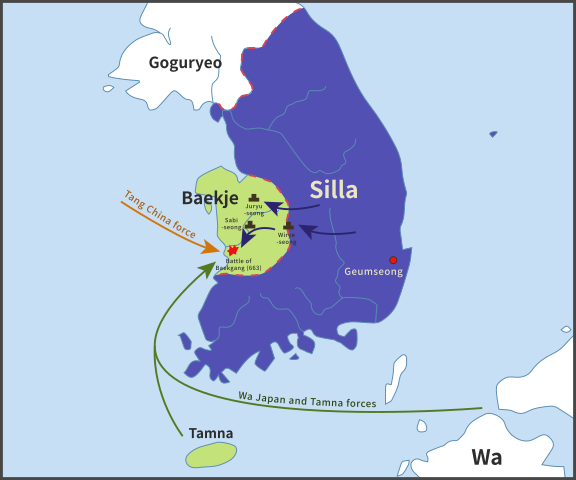
基肄城は、西日本にあった古代山城の一つです。663年に朝鮮で起きた白村江の戦いの後、朝廷により築かれました。日本は百済を助けようとしましたが、唐と新羅の連合軍に敗れたのです。天智天皇は、この連合軍による将来の侵攻の可能性を恐れ、百済からの難民の助けも借り、これらの城の築城を命じたのです。そのため、これらの城は「朝鮮式山城」とも呼ばれています。
Kii Castle is one of ancient mountain castles in western Japan. It was built by the Imperial Court after the Battle of Baekgang, Korea in 663. Japan tried to help Baekje, but was beaten by the ally of Tang and Silla. Emperor Tenchi, worried by the future possibility of invasion by this alliance, ordered the construction of these castles with the help of Baekje refugees. That’s why these castles are also called “Korean style mountain castles”.

白村江の戦いの図~The map about the Battle of Baekgang(licensed by Samhanin via Wikimedia Commons)

城特有の役割~Castle’s own Role
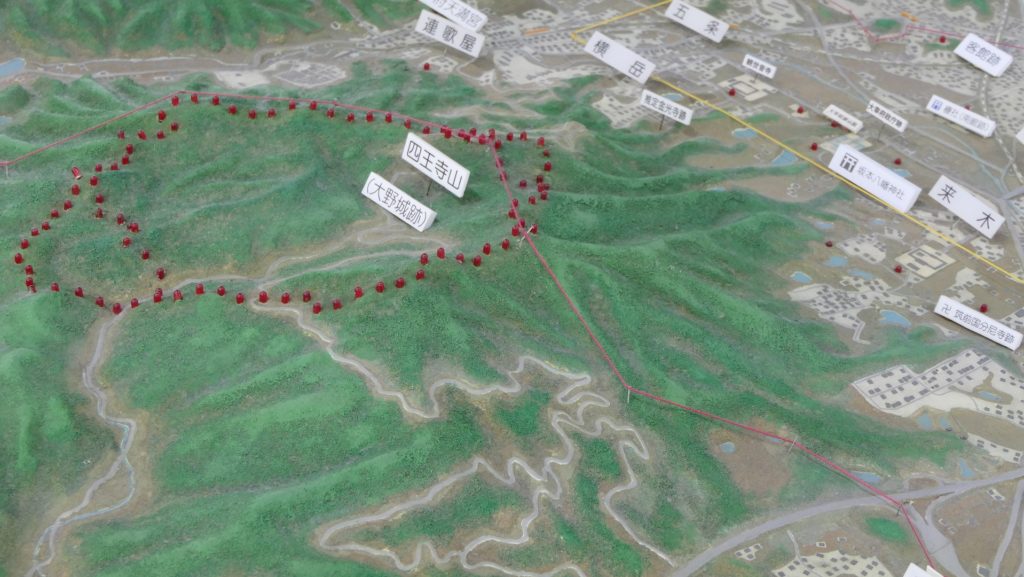
基肄城は、九州地方で記録がある五つのうちの一つです。その他は、大野水城麹池、そして金田です。それぞれの城には独自の役目がありました。基肄城は、物見のための城だったように思います。もし、連合軍が日本を攻めた場合、2つの考えられる侵攻ルートがありました。両方とも最初は金田城が築かれた対馬海峡にある対馬は通るでしょう。そして、壱岐島の辺りで2つに分かれることが推測され、一つは北の方角から博多湾経由で福岡平野に上陸し、もう一つは西の方角から有明湾経由で佐賀平野に上陸するものです。
Kii Castle was one of the five recorded ones in Kyushu region. The others were Ono, Mizuki, Kikuchi, and Kaneda. Each castle had its own role. I think Kii Castle was kind of a lookout castle. If the ally were to attack Japan, there would be two possible routes to enter from. Both would first pass through Tsushima Island on Tsushima Strait where Kaneda Castle was built. There are speculations that the routes may be divided around Iki Island, one would land on the Fukuoka plain through Hakata Bay from the north direction, and the other would land on the Saga plain through Ariake Bay from the west direction.

九州地方の5つの記録された古代山城の位置~The location of five recorded ancient mountain castles in Kyushu region

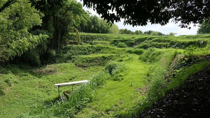
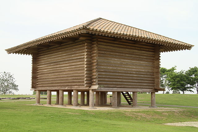
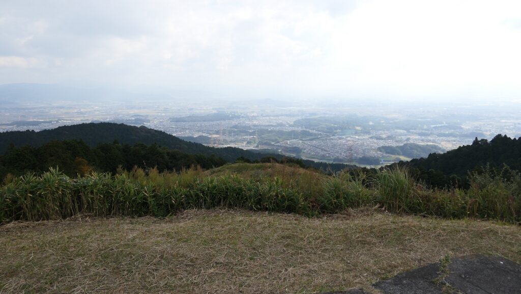
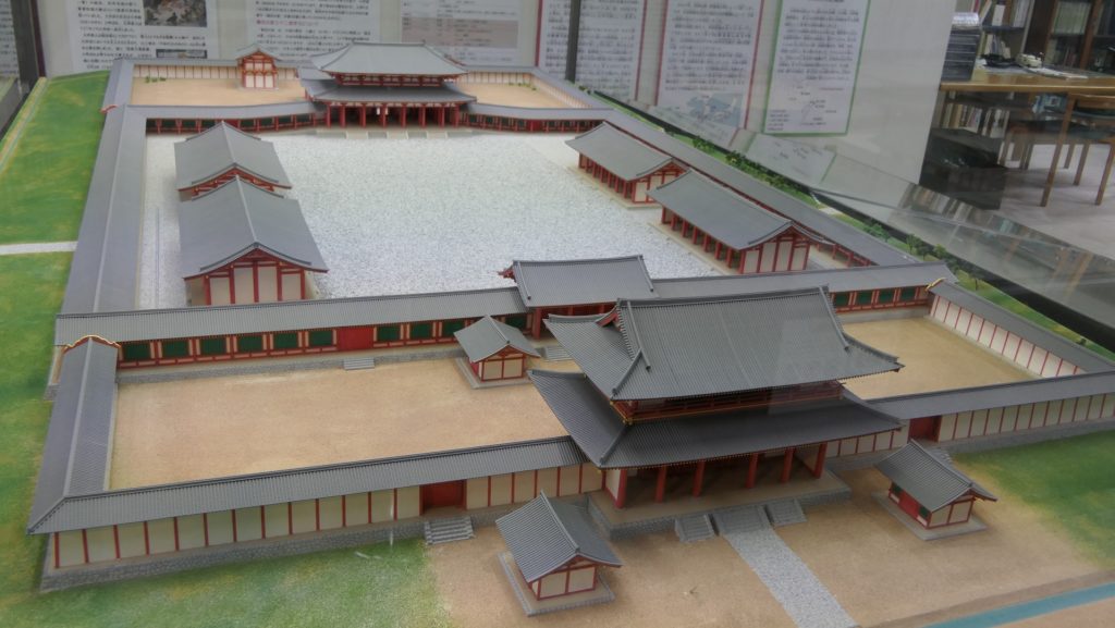
基山(標高404m)の上にあり、その頂上からは福岡、佐賀両平野が見渡せます。この城は主に佐賀の防衛の備えとされ、一方水城は福岡の方の備えとされました。基山には3つの峰(山頂、北峰、東峰)があり、南方になる谷を取り囲んでいました。それらの峰に沿って土塁が築かれ、その総延長は3.9kmありました。南側の谷には石垣が築かれ、排水口により水量を調整していました。城には4つの門があり、内側には倉庫や兵舎など多くの建物がありました。
Kii Castle was built on Kizan mountain (404m above sea level) and from its top both the Fukuoka and the Saga plains are visible. It was mainly prepared for the protection of Saga, while Mizuki was built for the protection of Fukuoka. Kizan mountain has three ridges (the top, the North Peak, and the East Peak) surrounding the valley on the south. The earthen walls were built along the ridges whose overall length was 3.9km. The stone walls were also built on the southern valley which had drains to control water. The castle had four gates and lots of buildings inside such as warehouses and barracks.

城周辺の起伏地図~The relief map around the castle

戦国時代に再利用~It was reused in Sengoku Period

古書によれば、基肄城は665年に築かれ、698年に修繕されました。結果的には連合軍は幸いにも日本を攻撃しませんでした。城の倉庫や兵舎は8、9世紀頃はで使われたとする歴史家もいます。15、16世紀頃、戦国時代として知られる時期には、その立地の良さから戦国大名によって再び城は使われました。
Old books say that Kii Castle was built in 665, and repaired in 698. As a result, the ally fortunately did not attack Japan. Some historians believe that the castle’s warehouses and barracks were used until around the 8th and 9th centuries. Around the 15th and 16th centuries which is also sometimes known as “Sengoku” Period or the Warring State Period, the castle was used again by some warlords, because of its good location.

戦国時代の城跡~The ruins of the castle in the Sengoku Period

特徴~Features

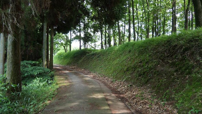
現在(2021年2月)、城跡の中心部に入ることと、全体を歩き通すことはできません。2018年の西日本での豪雨によりこの辺りが深刻な被害を受けたからです。行政がこの地域の道路と山道の通行を禁止しているのです。このため、観光客は行政が許可したいくつかの地点のみ見ることができます。それでは、現在行くことができる2つの地点をご紹介しましょう。
Now (in February 2021), it is impossible for anyone to enter the center of the castle ruins, and walk straight through the whole area. This is because the area was seriously destroyed by the heavy rain in western Japan in 2018. The local government bans the use of roads and trails in that area. For this reason, visitors are able to see only some spots that the Local Government has opened. I will describe two spots you can visit now.

城周辺の地図~The map around the castle

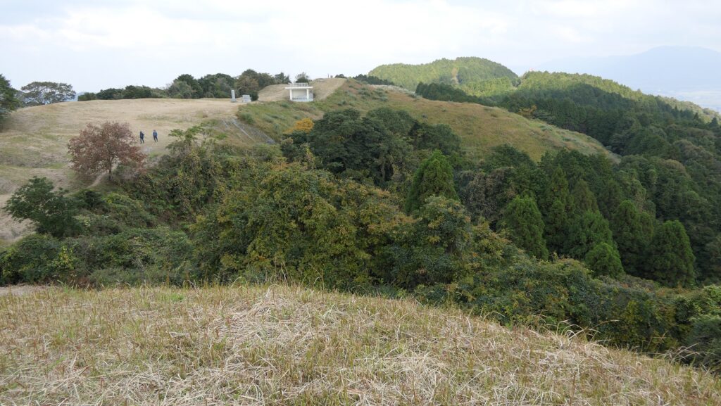
基山山頂~Summit of Kizan

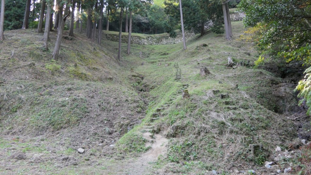
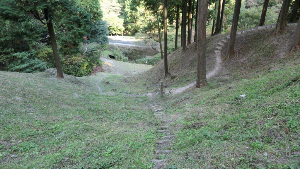
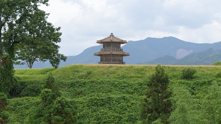
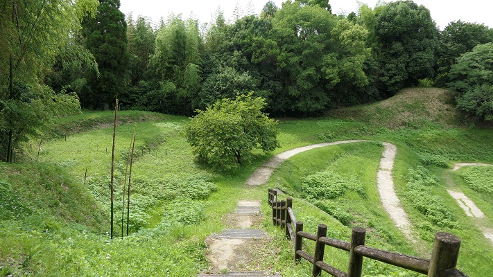
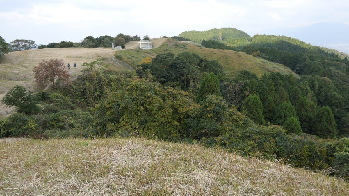
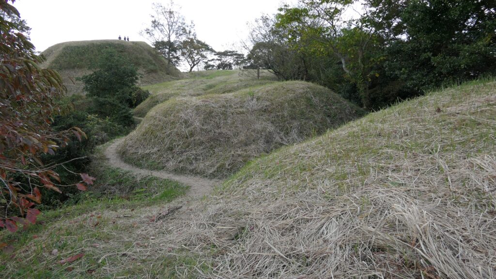
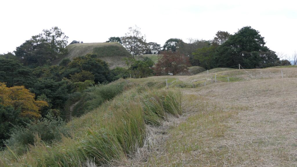
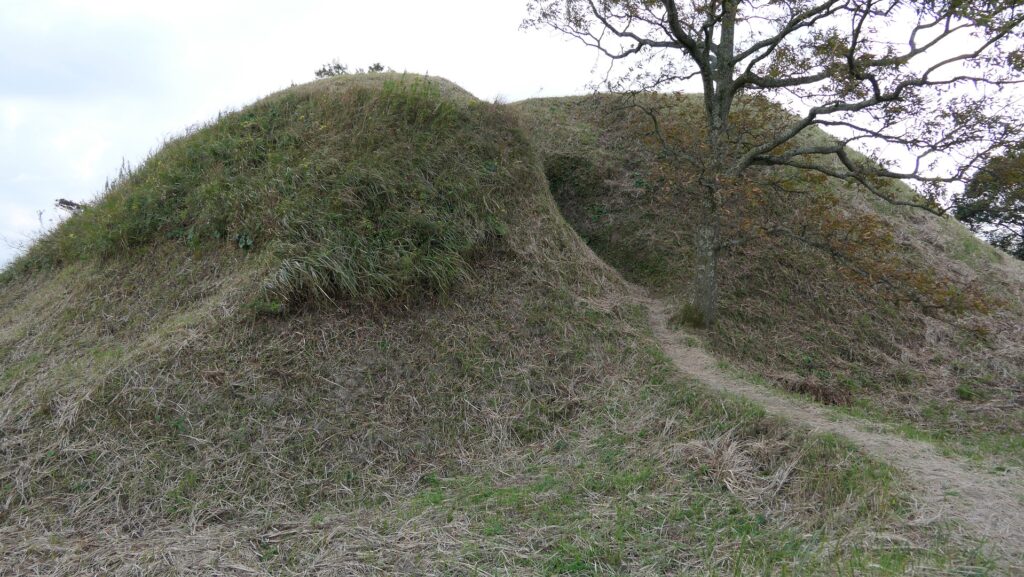
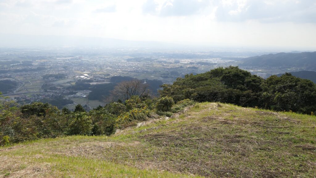
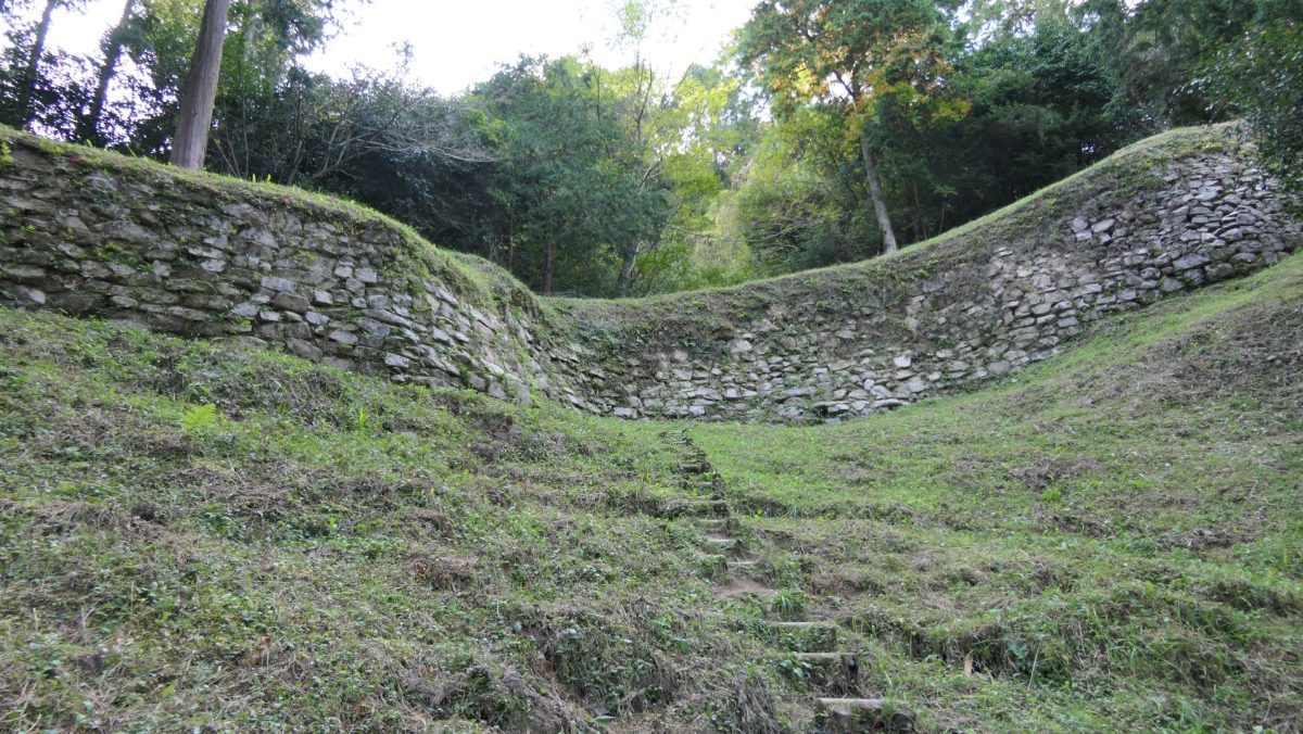
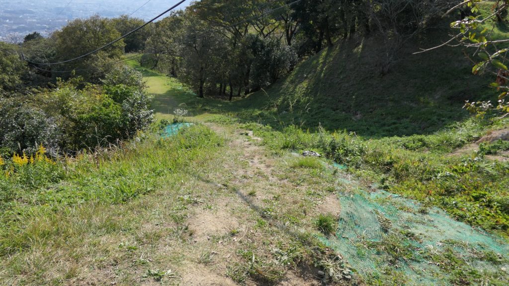
ここは城の最高地点だった所で、土塁の西側部分に当たります。そしてまた戦国時代の城の本丸でもありました。その外側は急坂になっていて、現在ではグラススキー場のゲレンデとして使われています。山頂の麓には駐車場があり、城跡を訪れる際駐車することができます。15分程山頂の方に登っていくと、その途中に沢山の溝が見えてきます。それは何か入口のように見えるかもしれませんが、実は戦国時代の城主により作られた「いものがんぎ」と呼ばれる空堀跡なのです。
This was the highest spot of the castle and the western part of the earthen walls, as well as the Main Enclosure of the castle in Sengoku Period. The outside is steep slope, so it is now used as a grass ski ground. There is a parking lot on the foot of the summit where you can park your cars while visiting the ruins. Its 15 minutes climb to the top and on the way you will see many ditches . You may think they are some of the entrances, but they are, in fact, ruins of dry moats called “Imono-gangi”, made by the lord of the Sengoku castle.

土塁外側の急坂~The steep slope outside of the earthen walls
「いものがんぎ」と呼ばれる空堀跡~The ruins of dry moats called “Imono-gangi”

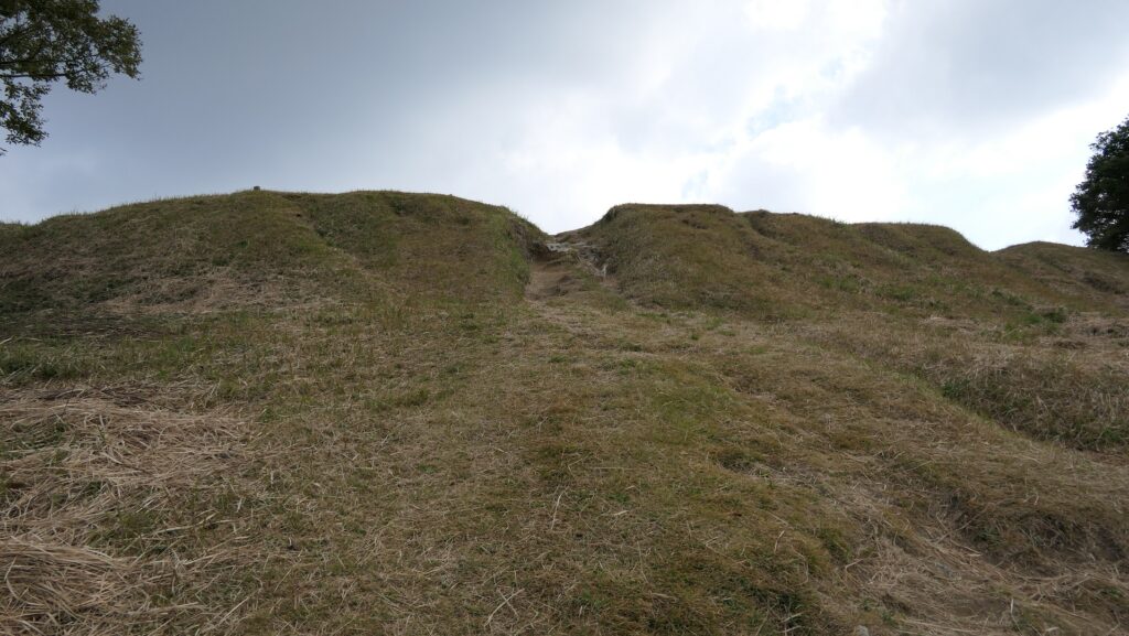
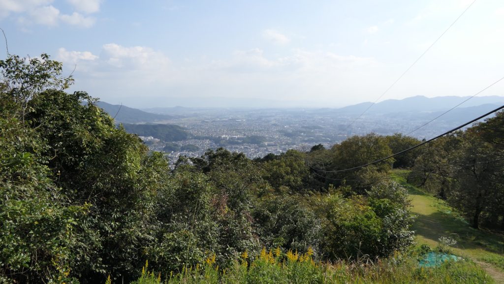
その空堀を越えていくと、土塁の上のよく開けた場所に至ります。土塁は南北に走っています。北の方角には基肄城を示す標識があり、福岡平野を望むことができます。
Over the dry moats, you will enter the widely open area, on the earthen walls. You can see the ridge of the mountain, the earthen walls, that goes both north and south. You can also have a view of the Fukuoka plain with the signboard of Kii Castle on the north.

基肄城の標識~The signboard of Kii Castle
福岡平野の眺め~A view of the Fukuoka Plain

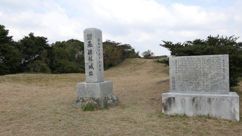
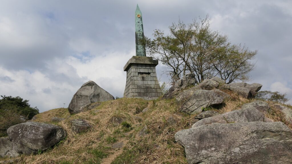
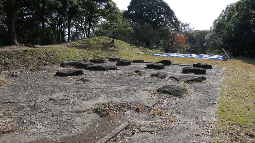
次に、反対側の南の方角に向かってみると、人工の土盛りが見えてきます。これらは戦国時代の本丸の跡なのです。この本丸は山の頂に作られたのです。もう一つ、天智天皇に関わる記念碑がここにあります。山頂からは、佐賀平野を見渡すことができます。
Next, if you go to the opposite side on the south, you can find artificial mounds, which are also the ruins of the Main Enclosure in Sengoku Period. The Enclosure is situated on the top of the mountain. There is another monument for Emperor Tenchi. You can also see the Saga plain from the top.

南の方角を見る~Lookng at the south direction
戦国時代の本丸跡~The ruins of the Main Enclosure in Sengoku Period
天智天皇の記念碑~The monument for Emperor Tenchi
佐賀平野の眺め~A view of the Saga Plain

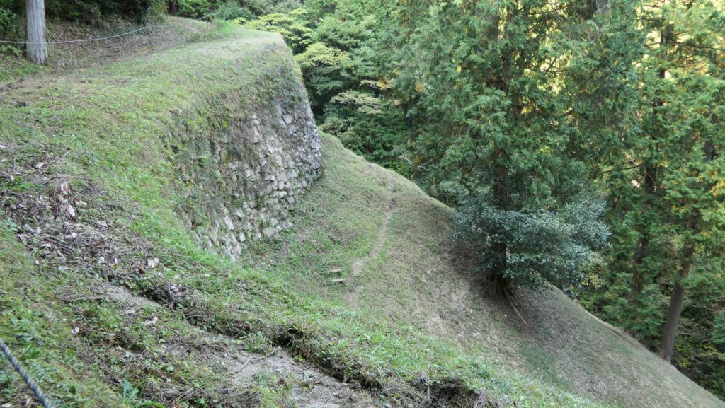
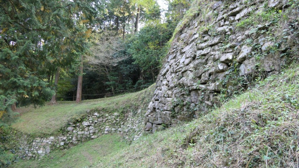
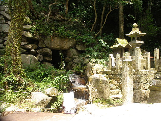
水門跡~Ruins of Water Gate

この場所は、城の南の部分に当たり、谷を埋めるため、水門と共に石垣が築かれました。石垣と水門の一部が今に残っています。ここに行くには違う道筋を進む必要があります。現存の石垣は全長26m、高さ8.5mあります。水門は石垣の下に設置され、住吉川の水を内側から外側に排出しています。
This spot was located on the southern part of the castle where the stone walls were built with the water gate to fill the valley. Part of the stone walls with the gate remain now. To visit them, you have to take a different route. The remaining stone walls are 26m long and 8.5m tall. The water gate is placed under the wall to drain the water of Sumiyoshi-gawa River from the inside to the outside.

水門跡~The ruins of the water gate(licensed by Wxrx via Wikimedia Commons)

その後~Later History

江戸時代(18、19世紀頃)においてでも、人々は基肄城が古代の遺跡であることを認識していました。というのは、公式の歴史書である「日本書紀」にこの城のことが記録されていたからです。城跡は最終的に1954年に国の特別史跡に指定されました。
Even in the Edo Period (around the 18th and 19th centuries), people recognized Kii Castle as ancient ruins, because the castle have been recorded in an official history book called “Nihon-Shoki”. The ruins were finally designated as a Special National Historic Site in 1954.

基肄城の土塁~The earthen walls of Kii Castle

私の感想~My Impression

私が基山山頂を訪れたとき、その山頂からは福岡・佐賀両平野の素晴らしい景色が見えました。そのときこの城はとても良い立地にあることが理解できたのです。役所によると城跡の中心地の道路は2022年3月までに復旧するとのことです。その後またこの城跡を訪れてみたいと思います。
When I visited the summit of Kizan, and saw great views both of the Fukuoka and Saga plains from the top, I really found out the castle had a very good location. The local government says that the roads in the center of the ruins will be repaired by March 2022. I would like to visit them again after that.

基山山頂付近~Around the top of Kizan mountain

ここに行くには~How to get There

ここには車で行くことをお勧めします。
九州自動車道の筑紫野ICから5km以内のところです。
もし基山町役場に立ち寄ることができれば、職員の方が城跡への道のりを詳しく教えてくれます。
I recommend you to go there by car at this point.
The ruins are within 5 km away from the Chikushino IC on Kyushu Expressway.
If you drop by at the Kizan Town hall, the officials will offer you the detailed routes to the ruins.

リンク、参考情報~Links and References

基肄城跡、基山町(Kizan Town Official Website)

86.大野城~Ono Castle

西の都「大宰府」の守護神
The guardian of the western capital “Dazaifu”

立地と歴史~Location and History

古代山城の一つ~One of Ancient Mountain Castles

大野城は西日本にあった古代山城の一つです。663年の朝鮮での白村江の戦いの後、朝廷によって築かれました。日本は百済を助けようとしますが、唐と新羅の連合軍に敗れてしまいます。天智天皇は、連合軍による日本侵攻を恐れました。そして彼は百済からの亡命者の助けを借りてこれらの城の建設を命じたのです。そのために「朝鮮式山城」とも呼ばれています。
Ono Castle was one of ancient mountain castles in western Japan. It was built by the Imperial Court after the Battle of Baekgang, Korea in 663. Japan tried to help Baekje, but was beaten by the ally of Tang and Silla. Emperor Tenchi was scared of invasion by the ally, so he ordered the construction of these castles with the help of the refugees from Baekje. That’s why these castles are also called “Korean style mountain castles”.

白村江の戦いの図~The map about the Battle of Baekgang(licensed by Samhanin via Wikimedia Commons)

これら古代山城は、姫路城、大阪城、名古屋城といった後の日本の典型的な城とは随分見かけが異なっていました。これらの城の主たる構造物は、山の頂を囲む土塁、石垣、貯水池、関門による外郭だったからです。城の内部には官庁、兵舎、倉庫のための建物があったようです。そのため、緊急事態時には平地から避難してきて、敵の侵入を防ぎながら生活と行政を続けられるようになっていました。
These ancient mountain castles looked very different from the typical castles built later in Japan, like Himeji, Osaka, and Nagoya castles, because their main structures were an outline surrounding the top of the mountain with earthen and stone walls, water reservoirs, and entrance gates. There seemed to be buildings for offices, barracks, and warehouses inside these castles, so in case of an emergency, people could escape from plain areas, and continue to live and govern preventing enemies’ invasion.

古代山城の一つ、鬼ノ城での復元例~An example of the restoration for Kino-Jo, one of the ancient mountain castles

大宰府を守る城~Castle protecting Dazaifu

大野城は、それらの中で間違いなく最重要の古代山城でした。「大宰府」と呼ばれた古代日本の地方行政府の背後にある「四王寺山」の上に立地していたからです。大宰府は通常、九州地方を統治していましたが、中国や朝鮮に近いため、国家の外交や防衛にかかわる重要な任務にも携わっていました。その庁舎や街並みは、日本の首都に準じて作られていました。
Ono Castle was definitely the most important ancient mountain castle among them, as it was located on a mountain called “Shioji-yama”, behind the ancient Japanese local government, “Dazaifu”. Dazaifu basically governed the area of Kyushu Region, but it also had very important duties, like taking care of Japan’s diplomacy and defense because it is located near China and Korea. The government office and town were built similar to the capital of Japan.

大宰府跡と四王寺山~The ruins of Dazaifu and Mt. Shioji-yama
大宰府政庁の模型~The miniature model of the Dazaifu office building(大宰府展示館~Dazaifu Site Exhibition Hall)

更に四王寺山は山城にもっともふさわしい山でした。その峰が平らな中心部を取り囲んでいるのです。峰を外郭にすることができ、建物を中心部に作ればよいのですが、まだ不十分でした。大量の労働力投入と、百済からの技術者の助けにより、版築という方式で峰に沿って土塁を築き、更には石垣を築き谷を埋めました。外郭の総延長は8.4kmにも及びました。
In addition, Shioji-yama mountain was the most suitable for the mountain castle. Its ridge rounds the flat center. The ridge could be the outline, and buildings could be built at the center, but it was not enough. People made great efforts to build earthen walls along the ridge using a method called Rammed earth, and further build stone walls to fill valleys with the help of the technicians from Beakje. The overall length of the outline reached 8.4km.

四王寺山の模型~The miniature model of Mt. Shioji-yama(大宰府展示館~Dazaifu Site Exhibition Hall

敵は来なかった~Enemy didn’t come

幸いにも連合軍は日本を攻撃しませんでした。日本の古書である「日本書紀」「続日本紀」には、大野城は665年に築かれ、698年に修繕されたとあります。しかしながら、いつしか廃城となってしまったようです。
Fortunately, the ally did not attack Japan. Japanese old history books such as “Nihon-shoki” and “Shoku-nihongi” say that the castle was built in 665, and repaired in 698. However, it seemed to have been abandoned at some point.

城の位置~The location of the castle

特徴~Features

現在、大野城の遺跡は主に外郭に沿って広がっています。そのため全てを見るにはかなりの時間がかかります。今回は、短時間で代表的な遺跡を見て回れるよう2つの地区をご紹介します。
Now, the ruins of Ono Castle are spread mainly along the outline, so it takes a lot of time to see all of them. This time, I will describe two areas where you can see representative ones in a short time.

城周辺の地図~The map around the castle

城周辺の起伏地図~The relief map around the castle

焼米ヶ原周辺地区~Around Yakigomegahara area

車であれば大宰府天満宮の前から四王寺林道を通って、四王寺山に至ります。そして焼米ヶ原駐車場に車を止められます。そこから歩いていくつかの遺跡を見ることができます。
You can drive from the front of Dazaifu Tenmangu Shrine up to Shioji-yama mountain through the Shioji forest road. Then, you will reach and park at Yakigomehara parking lot. From the parking, you can walk around several ruins.

・土塁線
ここは外郭の南側に当たり、部分的に二重になっています。城の中では重要な地点だったのでしょう。南の方向には街並みがよく見えます。
・The earthen walls line
This is the southern part of the outline, and was partly built doubly. It could be an important spot for the castle. You can have a good view of the town on the south.

土塁線~The earthen walls line
街並みの景色~A view of the town

・増長天礎石群
ここは建物の遺跡群のうちの一つです。4つの建物の礎石群が外郭に沿って残っています。今までに70以上の建物の跡が山の上に見つかっています。そのうちの多くは倉庫として使われたと考えられています。
・Zochoten foundation stone group
It is one of the groups for ruins of buildings. The foundation stones for four buildings remain along the outline. So far, over 70 ruins of buildings were found on the mountain. Many of them are thought to have been used as warehouses.

増長天礎石群~Zochoten foundation stone group

・大宰府口城門跡
これまでに見つかっている9つの城門の中では最大のものです。発掘の成果によれば、この城門は3回作りかえられているとのことです。城の正門であったのかもしれません。
・Dazaifu route Castle Gate Ruins
They are the largest castle gate ruins out of the nine castle gate ruins previously found in the castle. The excavation team found out that the gate was replaced three times. It might have been the front gate of the castle.

大宰府口城門跡~Dazaifu route Castle Gate Ruins(licensed by 小池隆 via Wikimedia Commons)

北部周辺地区~Around the northern area

山の中心の方に行き、県民の森センター前の交差点で右折して進むと、百閒石垣に着きます。道のかたわらに小さな駐車スペースがあります。
You can drive to the center of the mountain, then turn to the right at the intersection in front of Kenminnomori Center, and you will reach Hyakken stone walls. There is a small parking lot beside them.

百閒石垣を見上げる~Looking up Hyakken stone walls
百閒石垣から道路を見下ろす~Looking down the road from Hyakken stone walls

・百閒石垣
この城の中では最大の石垣で、全長は約180mあります(間は日本の古い長さの単位で1間は約1.8m)。この周辺は、城の北の入口に当たり、とても重要とされていました。この石垣は、基礎となる岩の上に、切り出した自然石を注意深く積んでできています。排水のための隙間もいくつか設けられています。朝鮮にはこれと似た山城の遺跡があり、朝鮮から来た技術者が工事を手伝った証拠とされています。
・Hyakken stone walls
They are the largest ones among the castle, which are about 180m across (Hyakken means 100 ken, ken is an old unit of length in Japan, 1 ken is about 1.8m.) and about 8m high. The area around was the northern entrance of the castle, and was considered very important. The stone walls were piled with chopped natural stones on the base rock very carefully. They also have some gaps that can drain water. There are similar stone walls of mountain castle ruins in Korea. That’s because technicians from Korea helped with the construction.

百閒石垣~Hyakken stone walls
石垣に近づきます~Getting closer to the stone walls
石垣までの坂はかなり急です~The slope to the stone walls is steep

その後~Later History

城の設立から約1世紀後、774年に城跡の上に四天王寺が創建されました。その当時新羅が日本を呪っていると言われていたため、それに対抗する祈りをこの寺で行ったのです。現在の山の名前はこの寺を由来としています。また「増長天」という建物の遺跡名は四天王のうちの一神を指します。戦国時代には山の中腹に岩屋城が築かれました。江戸時代には人々は多くの石仏を作り、信仰していました。最終的には城跡は1953年に国の史跡に指定されます。
About one century after the foundation of the castle, the Four Devas or Shitennoji Temple was founded on the castle ruins in 774. The temple was for praying against Silla that was said to have cursed Japan. The mountain became a castle for praying. The present name of the mountain comes from the temple. The name of the building ruins “Zochoten” is one of the four Devas. In the Warring States or Sengoku Period, Iwaya Castle was built on the mid-slope of the mountain. In the Edo Period, people made a lot of stone figures of the Buddha and prayed them. The ruins were finally designated as a National Historic Site in 1953.

石仏のうちの一体~One of the stone figures of the Buddha(taken by ヘンリー3世 from photoAC)

私の感想~My Impression

少なくとも百閒石垣は見ていただきたいです。1350年以上のもの間、このような石垣が生き残ってきたことに驚きを感じます。実際にご覧いただければ、この石垣がまだまだ頑丈であることがわかると思います。当方もいつの日か1日かけて城跡全体を歩いてみたいです。
I recommend you to at least see Hyakken stone walls. You can also see it’s surprising that such stone walls have survived for over 1350 years. The stone walls still look very strong when you look at them. I also think that I will spend a day walking around all the ruins sometime.

百閒石垣~Hyakken stone walls

ここに行くには~How to get There

城跡に行くには、車を使われることをお勧めします。
九州自動車道の大宰府ICから約5kmです。
I recommend you to go there by car.
The ruins are around 5 km away from the Dazaifu IC on Kyushu Expressway.

リンク、参考情報~Links and References

大野城跡、大野城市(Onojo City Website)
大野城跡、宇美町(Umi Town Website)
・「マンガ版大野城物語」古代山城サミット実行委員会(Japanese Comic)

189.鞠智城~Kikuchi Castle

It was mysterious, but its achievement took root.
この城は不思議な存在でしたが、その成果は地域に根付きました。

外郭から見た復元された鼓楼~The view of the restored drum tower from the outline

立地と歴史~Location and History

鞠智城は西日本における古代山城の一つです。663年の朝鮮での白村江の戦いの後、朝廷によって築かれました。日本は百済国を助けようとしたのですが、唐と新羅の連合軍に敗れてしまったのです。天智天皇は連合軍の日本への侵攻を恐れ、山城の建設を命じ、それは百済からの難民の力を借りて行われました。そのため、これらの城は「朝鮮式山城」とも呼ばれています。
Kikuchi Castle was one of ancient mountain castles in western Japan. It was built by the Imperial Court after the Battle of Baekgang, Korea in 663. Japan tried to help Baekje, but was beaten by the ally of Tang and Silla. Emperor Tenchi was scared of invasion by the alley, so he ordered to build these castles with the help from the refugees from Baekje. That’s why these castles are also called “Korean style mountain castles”.

白村江の戦いの図~The map about the Battle of Baekgang(licensed by Samhanin via Wikimedia Commons)

鞠智城は、九州地方で記録されている5つの山城のうちの一つです。その他は、大野城、水城、基肄城、金田城です。これらの城は侵攻があった場合に想定される進路に沿って置かれました。しかしながら、鞠智城については少し変なのです。大野城が近くにある大宰府政庁からは60kmも離れていて、もう一つの想定攻撃路である有明湾からも30km離れていました。この城は補給基地であったとか、やはり有明での攻撃に備えたものだという人もいます。ある歴史家は、百済からの難民の収容施設だったのではないかと言っています。なぜならこの周辺地域は、百済との貿易や文化面で関わりがあったからです。事実、この遺跡の貯水池跡から百済観音像が発見されました。加えて、この場所は他の古代山城と比べて低い位置にあり、居住にも適していました。
Kikuchi Castle was one of the five recorded ones in Kyushu region. The others were Ono, Mizuki, Kii, and Kaneda. They had their locations on the way or alongside of expected routes for the invasion. However Kikuchi was a little strange. It was about 60 km away from the Dazaifu government, near Ono Castle, and nearly 30 km from Ariake Bay, another possible attack route. Some speculate it could have been a supply base or preparation for an attack on Ariake. A historian says that the castle could nave been an accommodation for refugees from Baekje, because the area around the castle had been related to Baekje’s in trading and culture. Indeed, a Baekje Buddha statue was excavated from the ruins of the water reservoir. In addition, this site is lower than other ancient mountains castles that made it livable for people.

九州地方の5つの記録された古代山城の位置~The location of five recorded ancient mountain castles in Kyushu region

その後侵攻の危機は去ったのですが、この城は10世紀まで約200年に渡って使われました。この城の歴史の後半においては、軍事拠点、政庁、それに倉庫として使われたようなのです。城の周辺地域は肥沃になり、貿易でも繁栄しました。城が廃城となって約300年後、菊池氏が日本の武士団の頭領となり、侵攻してきた蒙古軍と戦いました。
Despite the crisis of the invasion being resolved, the castle was used for about 200 years until the10th century. In the later stages of its life, it seemed to be an army base, government office, and storage. The area around the castle became fertile and prosperous with trading. About 300 years after the castle was abandoned, the Kikuchi clan fought with the Mongolian Invasion as the leader of Japanese warriors.

菊池武房、「蒙古襲来絵詞」より~Takefusa Kikuchi from “The picture scrolls of the Mongol invasion attempts against Japan”(licensed under Public Domain via Wikimedia Commons)

特徴~Features

近世の城が持つイメージとは違い、この城の主な構造物は、外周が3.5kmに及ぶ外郭部分です。そこには4つの門があり、その間には版築による土塁が続いていました。
Unlike the image of early modern age castles, the main structure of the castle is outlined with a perimeter about 3.5 km long. It had four gates and walls between them were made from rammed earth.

城周辺の地図~The normal map around the castle

外郭土塁の一部~Part of the earthen walls on the oitline

外郭沿いの歩道は現在トレッキングコースになっています。門跡を一つ一つたどっていくことで、城がどのくらいの大きさだったのかがわかります。
The path along the outline is now used for trekking. You can see the ruins of the gates one by one, and feel how large the castle was.

歩道は外郭の土塁に沿っています~The path goes alongside the earthen walls on the outline

駐車場から一番近いのは深迫門で、通用門として使われたとみられます。
The nearest one from the parking lot is Fukasako Gate which could have been used as the side entrance.

深迫門跡~The ruins of Fukasako Gate

次に現れるのは堀切門で、ここが正門だったようです。
The next comes Horikiri Gate which could have been the main entrance.

堀切門跡~The ruins of Horikiri Gate

池の尾門というもう一つの門跡まで見て回ることができます。
外郭の内側には、恐らく鼓楼として使われたであろう三層の塔があり、最近発掘の成果により復元されました。この塔は平面が八角形でした。これは百済から取り入れた様式であり、古代日本ではとても珍しいものです。
You can go ane see another ruins of gate called Ikenoo Gate.
Inside of the outline, the three-layer tower, probably used as the drum tower, has been restored recently with the success of excavation. This tower is octagonal which came from the Baekje style, making it very unique to ancient Japan.

復元された鼓楼~The restored drum tower

兵舎や倉庫といった別種の建物も復元されています。
Other types of buildings such as barracks and warehouses have also been restored.

復元された兵舎~The restored barrack(licensed by 小池隆 via Wikimedea Commons)
復元された倉庫~The restored warehouse(licensed by 小池隆 via Wikimedea Commons)

その後~Later Life

10世紀に廃城となった後、城跡は畠となりました。それもこの地域の繁栄を表しているのかもしれません。この地域が最初に遺跡として調査されたのは1937年のことでした。1967年から2010年に渡っては32回も発掘が行われました。それ以来、研究者はシンポジウムを開催し、この城についての議論を深めています。城跡は歴史公園「鞠智城」として整備されており、鼓楼などの建物が復元されています。
After being abandoned in the 10th century, the ruins of the castle were turned into a farm. That might have shown the prosperity of this area. This area was first researched as ruins in 1937. It was excavated 32times between 1967 and 2010. Since then, while researchers have held symposiums and debated issues with the castle, the ruins has been developed as a historical park called “Kikuchi Castle”. Several buildings such as the drum tower have been restored.

1970年代の城跡周辺の航空写真~The aeriel photo of the area around the castle ruins in the 1970s

最近の城跡周辺の航空写真~The recent aerial photo around the castle ruins

今でもまだ畠が少し残っています~Few farm still remains now

私の感想~My Impression

この城跡は西側に面しているため、晴れた日の夕方には美しい夕日を見ることができます。それは絶好の写真スポットでもあります。私としては、公園の中央にある復元建物を見るだけではなく、歩道に沿った門の跡も見て回っていただきたいです。もっとこの城のことが理解できるでしょう。できたら岡山県の鬼ノ城のように門の一つでも復元されたらと思います。そうすれば世界中から観光客を呼び寄せることも可能かもしれません。
As the ruins face the west direction, you can see the beautiful sunset on a sunny evening. It can also be a good photo spot. I recommend visiting the restored buildings at the center of the park as well as the ruins of the castle’s gate ruins along the sidewalk to know more about the castle. I hope a gate might someday be restored, like Ki-no-Jo in Okayama Prefecture. That way, the castle may attract many people from around the world.

復元された鬼ノ城の西門~The restored Western Gate of Ki-no-Jo

ここに行くには~How to get There

ここに行くには車がお勧めです。九州自動車道植木ICから約20分、熊本空港から約40分かかります。歴史公園に駐車場があります。
I recommend using a car to get there. It takes about 20 minutes from the Ueki IC on Kyushu Expressway, or about 40minutes from Kumamoto Airport. The park offers a parking lot.

リンク、参考情報~Links and References

歴史公園鞠智城・温故創生館(Only Japanese?)
・「古代山城「くくちのき(鞠智城)」九州王朝再興の夢舞台」松見正宣著、文芸社(Japanese Book)
・「古代山城 鞠智城を考える―2009年東京シンポジウムの記録」笹山晴生監修、山川出版社(Japanese Book)