27.上田城(Ueda Castle)

Location and History

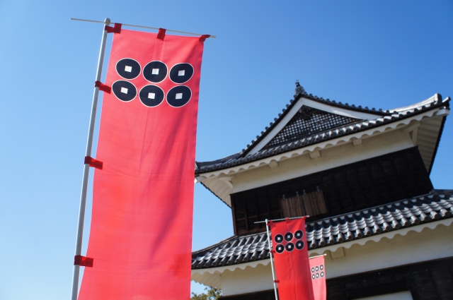
上田城は、長野県上田市の最も有名なシンボルの一つです。この城は真田氏によって築城されました。城に向かう道すがら、真田の旗印である「六文銭」(三途の川の渡し賃の意味)がたくさん目に入ってきます。
The Ueda castle is one of the most famous symbols of Ueda city in Nagano prefecture. The castle was founded by the Sanada clan. You can see a lot of Sanada’s flag of “Rokumonsen” (six one-mon coins), which is the fee for crossing the Styx, which is beside the castle.

「六文銭」旗印と上田城(The flag of “Rokumonsen” and Ueda Castle)taken by 松波庄九郎 from photo AC

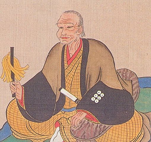
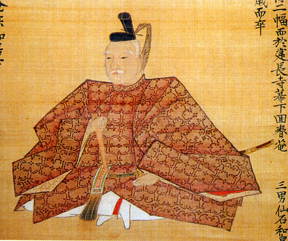
戦国時代後期の大名、真田昌幸が1583年に最初に上田城を築きました。彼は、真田一族の独立を意図し、後に幕府を開くことになる徳川氏に反抗しました。徳川は2回この真田の城を攻めたのですが、真田は負けませんでした。特に、1600年の天下分け目の合戦の中で行われた2回目の戦いがよく知られています。それ以来、真田とこの城が有名になったのです。徳川は激怒し、天下を取った後この城を完全に破壊させました。
Masayuki Sanada, a lord in the late Civil war period first built Ueda castle in 1583. He aimed to make his clan more independent against the Tokugawa clan which would become the Shogunate. Tokugawa attacked the Sanada castle twice, but they couldn’t be defeated. The second one was particularly a well-known battle among the fateful battles in 1600. That had made Sanada and this castle famous from then on. However, Tokugawa was so angry that they ordered to have the castle completely destroyed after the clan came to power.

真田昌幸像、個人蔵(The picture of Masayuki Sanada, privately owned)licensed under Public Domain, via Wikimedia Commons

結果的として実は、真田の城がどんなだったかはわからないのです。江戸時代になって、仙石忠政が上田藩の藩主として移封されてきたとき、城の再建を許可されました。忠政は真田の城を再現しようとしたのですが、それを果たす前に亡くなってしまいました。今、私たちが目にしているのは、忠政によって残された土木建築の一部なのです。
As a result, in fact, the structure of Sanada’s castle is uncertain. In the Edo period, when Tadamasa Sengoku was transferred to the lord of the feudal domain of Ueda, he was allowed to rebuild the castle. He tried to recreate the Sanada castle, but he died before it had done. Now we can see part of the remaining buildings and constructions made by Sengoku.

仙石忠政像、上田市立博物館蔵(The picture of Tadamasa Sengoku, owned by Ueda City Museum)licensed under Public Domain, via Wikimedia Commons

Features

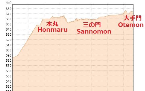
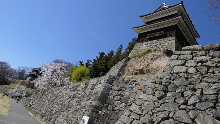
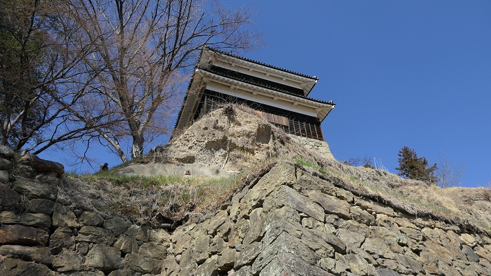
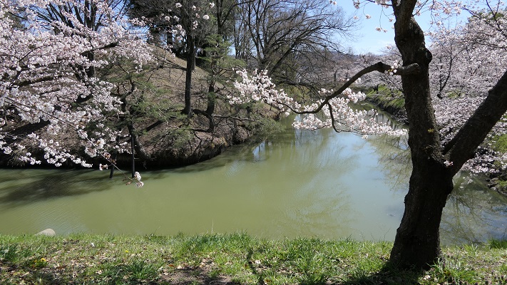
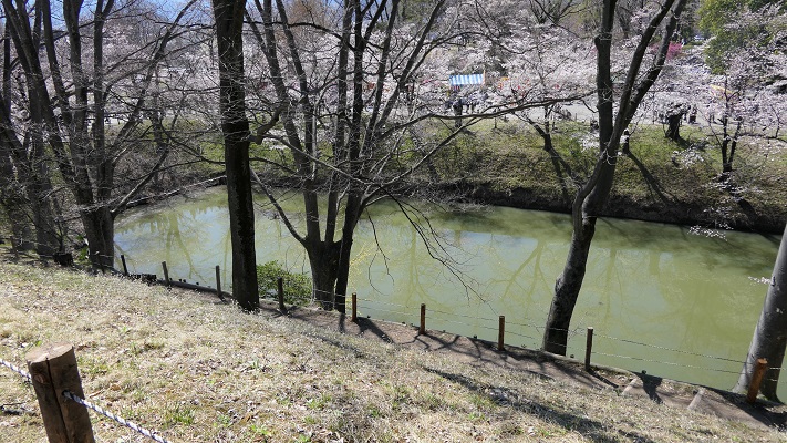
現在、「本丸」とそこにある3棟の「櫓」の建物、そして「二の丸」が残っています。本丸は高く盛られていて、北・東・西の三方向を水堀と二の丸によって囲まれています。過去においては、その三方向の外側が更に川と湿地帯よって守られていました。
Now, the main enclosure “Honmaru” with the buildings of three turrets “Yagura” and the second enclosure “Ninomaru” remains. Honmaru is highly elevated and it is surrounded by a water moat and Ninomaru in north, east and west directions. In the past, the outside of the three directions were also protected by rivers and waterlogged areas.

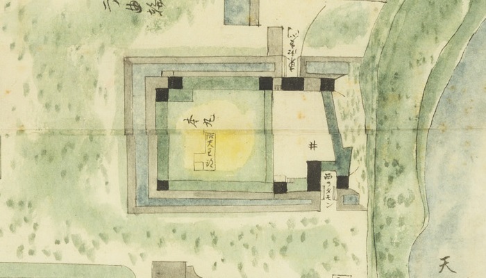
最新の城周辺地図(The latest map around the castle)


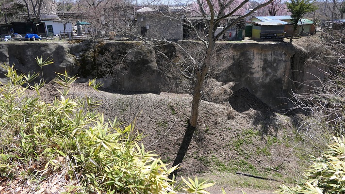
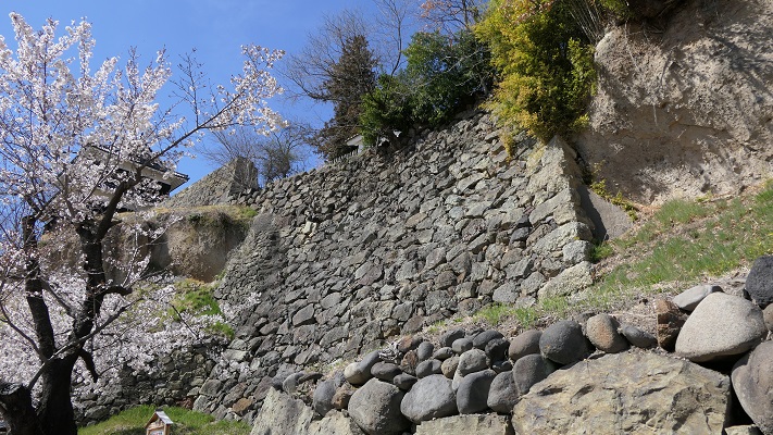
本丸の南の方は、急崖による天然の要害になっていて、現在でも見ることができます。更には、「尼ヶ淵」という今は干上がっている沼沢があり、崖に沿って流れている千曲川につながっていました。それも障壁だったのです。
The south of it has natural hazard with a steep cliff which can be seen today. In addition, a pool called “Amagafuchi” which drys up now, connected to the Chikuma River that flows alongside the cliff. it was another hazard.

本丸の南面(The south side of Honmaru)

(’19-9-10 追記 added)
上田城に天守があったかどうかははっきりしません。「武家事記」という古書では初期の上田城のことを「天守も無き小城」と述べている一方、江戸時代の寛政年間の古地図には「御天守跡」との記載があります。よって歴史家の意見は分かれていました。しかし最近になって本丸の辺りから、天守で使われたような金箔瓦が出土したのです。現在、多くの歴史家は天守か、それに準ずる豪華な櫓があったのではないかと考えています。
It is uncertain whether Ueda Castle had the keep “Tenshu” or not. While an old book “Buke-Jiki” calls the early castle “A small castle even without the Tenshu”, another old map in the Kanei Eea, Edo peried records “The ruin of the Tenshu”. So historians’ opinion remained devided. But, recently an old roof tile with gold leaf that might have been used for Tenshu was excavated from the Honmaru area. Now, many historians think the castle had the Tenshu or a similar luxury turret “Yagura”.

「御天守跡」の記載がある古地図「上田城構之図」部分(The part of the old map called “Ueda-Jo-Kamae-no-Zu” recording “The ruin of the Tenshu”)、協力:上田市マルチメディア情報センター

Later Life

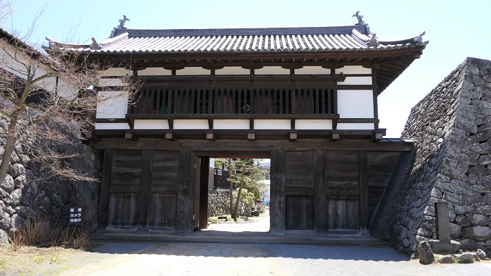
明治維新の後、2つの櫓が売られていき、遊郭の建物として使用されました。最悪の時には、たった一つの櫓(西櫓)を残すのみとなり、他は撤去されてしまいました。
After the Meiji restoration, two of those turrets were sold and used as Geisha houses. At the worst time, only one turret (the West Yagura) remained and the others were removed.

西櫓(The West Yagura)

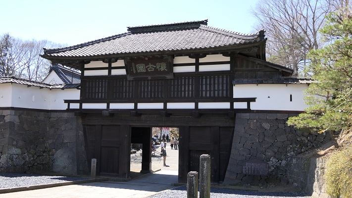
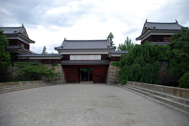
第二次世界大戦後、市民たちは売られた2つの櫓を買い戻すことに成功し、元あった場所に据え付け直しました(北櫓と南櫓)。最近になって、東虎口櫓門と袖塀が忠実に復元され、北と南の櫓をつなぎました。この辺りの外観が、昔ながらの姿に正確に再現されたことで、絶好の写真スポットになっています。
After the World War II, citizens were successful to get the bought turrets back and placed them to their original positions (the North and South Yagura). Recently, the East entrance gate and side walls were rebuilt in the original way connecting the north and south Yagura. Their appearance has become an accurate representation of the past, and has become a good photo spot.

東虎口櫓門と南北櫓(The East Entrance between the North and South Yagura)taken by チャコ from photo AC

My Impression

先ほど申し上げました通り、真田の城そのものは現在見ることはできません。しかし、後に続いた城主仙石忠政は、英雄である真田にちなんで築城できないかどうかと考えたのではないでしょうか。だから真田の城の思想は、忠政の城に引き継がれていると思うのです。それが正しければ、今現在存在する城を見て、真田の城がどうあったかというのも理解できるはずです。
As mentioned above, we can’t see the structure of Sanada’s castle. But I imagine that the following lord Sengoku was wondering if he could build his castle after the brave Sanada. So I think the idea behind Sanada’s castle could led to the castle by Sengoku. If that was true, we can understand how Sanada created their castle by examining the castle now.

忠政が掘り起こした本丸の水堀(The water moat at Honmaru that Sengoku dug up once again)

この城は、高低差、自然の要害、人口の構築物をうまく使って、少ない兵で敵から守れるようコンパクトに作られたのだと言えます。
I can say the castle was made compact to prevent enemies with a small number of soldiers, using different elevations, natural hazard, and artificial structures.

本丸から二の丸を見下ろす(A view looking down Ninomaru from Honmaru)

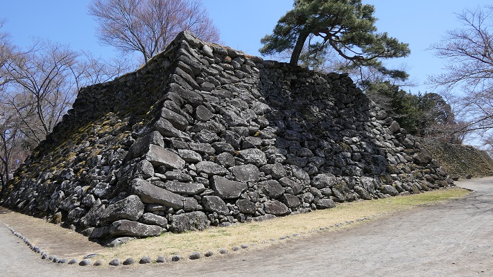
南面の崖に行ってみて、崖の崩壊を防ぐため各時代に作られた様々な石垣を見てみるのもおすすめです。
I recommend you see the south side cliff where you can also find many kinds of stone walls to prevent the cliff from collapsing in different times.

南面の様々な石垣(The different kinds of stone walls on the south side)

How to get There

上田駅から歩いて15分くらいです。
東京から上田までは、直通の北陸新幹線があります。
It takes about 15 minutes on foot from the Ueda train station.
There is a direct train from Tokyo to Ueda via the Hokuriku Shinkansen super express.

Links and References

上田城・上田城跡公園~信州上田観光協会(Uedajo Castle~Ueda City Tourism Association)

28.小諸城(Komoro Castle)

Location and History

小諸城は少し変なところにありました。この城は、かつての小諸宿、現在の小諸市の中心部のすぐ近くに位置していました。基本的に城というのは周りの土地より高いところに作られました。なぜならその方が守備側から攻めやすく且つ守りやすいからです。また、町の人々に権威を見せつけることもできます。しかしながら、この城は町より低いところにありました。城の中心部に行けば行くほど低くなっていくのです。そんなわけでこの城は「穴城」とも呼ばれています。そんな立地の理由は恐らく城の地形にあるのでしょう。城は、急崖と深い溝を伴った河岸段丘の端にあります。町の反対側から攻めるのは難しすぎます。城の築城者は、利点と不利な点を勘案し妥協したのではないでしょうか。

最新の城周辺の地図(The latest map around the castle)


The Komoro Castle had a little strange location. The castle was located just near the Komoro traditional post town, now at the center of the Komoro city. Basically, castles were set on higher places than surrounding areas because that way defenders easily attack and protect against enemies. It can also show authority to people. However, this castle was lower than the town. The more one approaches the center of the castle, the lower the altitude is. So the castle is also called “the hole castle”, “Anajo”. The reason for such a location would be the terrain of the castle. It is at the edge of a river terrace with steep cliffs and ditches. It is too difficult to charge from the opposite side of town. The founder of the castle seemed to compromise between its advantages and a disadvantage.

小諸城の土地の断面図(The cross section of Komoro castle’s ground)

小諸城は最初は15世紀に建てられたと言われています。戦国時代には、武田氏が周辺の地域を支配しました。江戸時代の初期には城主であった仙石氏がこの城を完成させました。防衛の必要性からこの城は町の方向に曲輪を広げていったのです。そして主な曲輪の入り口には、大きく堅固な門がありました。その内の2つの門が現在残っていますが(「三の門」と「大手門」)、他の門は撤去されました。両方とも重要文化財に指定されています。

三の門(Sannomon)

It is said that Komoro Castle was first built in the 15th century. In the civil war period, the Takeda clan governed the area around it. At the beginning of the Edo era, the lord of the Sengoku clan completed the castle. Because of the need for defense, the castle had spread enclosures around the town. The major enclosures had large and well constructed entrance gates. Two of these gates remain now (“the third gate” “Sannomon” and “the main gate” “Otemon”), but the others were demolished. Both are designated as the important cultural properties.

大手門の内側(The inside of Otemon)

Features

城の主要部分は現在、「懐古園」の名で公園として使われています。ここでは桜園、博物館、動物園、そして城跡と見所がたくさんあります。三の門は今、懐古園の正面入り口として使われており、公園の名前が書かれた額と共に移っている写真で日頃から有名です。
The main area of the castle has now been turned into the public park, “Kaikoen”. It offers many attractions like cherry blossoms, museums, a zoo, as well as the ruins of the castle. The Sannomon gate is now used as the main gate of Kaikoen which is usually famous for pictures with the park name tablet.

「懐古園」の額と三の門(The tablet of “Kaikoen” and the Sannomon)

いろいろ楽しんだ後、公園の端の方に行ってみると、少々驚かれるかもしれません。そこは高い崖に囲われていて、周辺一帯の見事な景色を見ることができるのです。そう感じるのは、小諸城の独特の構造によるものなのでしょう。
After enjoying these attractions, when you reach the edge of the park, you might be surprised that the park has a great view of the area around it with high cliffs. That’s because of the structure of Komoro Castle.

城の端地点からの景色(A view from the edge of the castle)

大手門は現在、公園の反対側の方にあります。明治時代に鉄道が城の中を通って、隔てられてしまったからです。この門は一時民間に売却されて、料亭や塾の建物として使われていました。最近になって行政が買い戻して、元の外観に戻す復元工事を行い、今は一般に公開されています。
The Otemon gate is now on the opposite side of the park, as the train line divided the castle in the Meiji era. The gate was once sold to the private sector, and used as a traditional Japanese restaurant or a private school. Recently, officials bought it back, restored it to its original appearance, and now open to the public.

大手門の外側(The outside of Otemon)

(’19-9-5 追記 added)
なお、城には天守が今も残っている天守台の上にありましたが、1626年に落雷により焼け落ちてしまいました。
In addition, the castle had the keep “Tenshu” on the now remaining base of Tenshu. But it was burned down by a stroke of lightning in 1626.

現存する天守台(The remaining base of Tenshu)

Later Life

江戸時代が終わったとき、城は廃城となりましたが、小諸藩士の多くがこの城の行く末を憂えました。彼らは資金を集め、城の主要部分を買い取ることができました。そして、そこを「懐古園」と名付け、懐古神社を設立したのです。現在の持ち主(藩士の子孫たち)は、市に公園として貸しているとのことです。

本丸にある懐古神社(The Kaiko shrine at Honmaru area)

When the Edo Period ended. The castle was closed, many of warriors worried about the future of the castle. They collected money and were successful to buy the main area of the castle. They named it “Kaikoen” and established the Kaiko shrine. Now the owners (descendants of the warriors) lend the area to officials as the park.

My Inpression

私も最初はこの城跡は古門や石垣を除いては普通の公園のようだと感じたのです。しかし、奥に歩いていくにつれて、なぜ築城者がここに城を作ったのかわかった気がしました。
At first, I felt that the ruins were just like a park except for the old gates and remaining stone walls. But I walked to the edge of them, and I was able to understand why the founder built the castle there.

自然の地形を生かした堀切(The ditch using natural terrain)

地理に興味がある方は、城の周りを見て歩くのもいいかもしれません。典型的な河岸段丘とともに、高い崖に様々な地層を見ることができます。
For those who are interested in geography, it is a good idea to look around the area. You can see geological formations on the high cliffs with typical river terraces.

近くの崖に見られる地層(A geological formatioon on a cliff nearby)

How to get

ここに行くには電車がベストでしょう。なにしろ小諸駅が城の一部であった所にあるからです。車で行く場合には、懐古園に駐車場があります。
東京から小諸駅まで:北陸新幹線で軽井沢駅まで行き、しなの鉄道の普通列車に乗り換えてください。

It is best to use train to access it, as the Komoro train station was built on part of the castle area. When using a car, the Kaikoen park offers a parking lot.
From Tokyo to Komoro st.: Get the Hokuriku Shinkansen super express to Karuizawa st., and transfer to the Shinano Railway local line.

Links and References

こもろ観光局(The Komoro Tourism Bureau)