193.臼杵城~Usuki Castle

「丹生島」と呼ばれた島の全体が城そのものでした。
The whole of an island called “Niu Island” was the castle itself.

西側から見た「丹生島」の全景~The whole view of “Niu Island” from the west

立地と歴史~Location and History

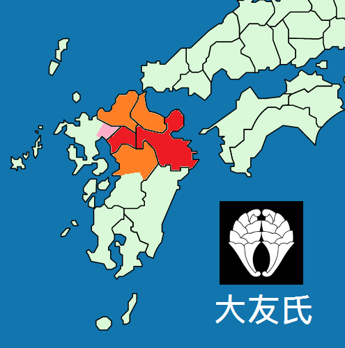
臼杵城は、もともと「丹生島城」と呼ばれていて、こちらの方が歴史ファンにはなじみがあるかもしれません。なぜならここは戦国時代に大友氏と島津氏の間で起こった有名な「丹生島城の戦い」の舞台となったからです。大友氏は北部九州地方において6箇国を領有し、その本拠地は豊後国の府内、現在の大分市にありました。
Usuki Castle was originally called “Niu Island Castle” which is rather popular among history fans. Because there was a famous battle between the Otomo and Shimadu clans called “the Battle of Niu Island Castle” in the Warring States Period, Otomo clan had their territory of six provinces in the north part of Kyushu region, whose home base was in Funai of Bungo Province, now called Oita City.

16世紀中頃の大友氏の勢力圏~The Otomo clan’s territory in the mid 16th century(licensed by Alvin Lee via Wikimedia Commons)

大友宗麟は、1561年に毛利氏との戦いに敗れた後、より防御力の強い拠点を作る必要を感じました。宗麟は、臼杵湾にある岩でできた丹生島に新しい本拠地を作る決断をします。この島は約4kmの外周があり、海面から15mの切り立った岩崖がありました。更には、この城は引き潮のときは砂浜経由で行き来できましたが、満ち潮のときは完全に陸地から離れていました。もし戦いが起こった場合、十分な兵糧か水軍による補給があれば、長期間の籠城が可能となっていました。
Sorin Otomo found his clan in need of building a more defensive site after they were beaten by the Mori clan in 1561. He decided to build their new base castle on the rocky Niu Island in the Usuki Bay. The island was about 4 km surroundings in length, and 15m height from sea surface with vertical rock cliffs. In addition, the castle was accessible through the sandy beach at low tide, or completely isolated from land at high tide. If a battle happened, it could persevere for a long time with enough supply of its own or from the Navy.

大友宗麟肖像画、瑞峯院蔵~The portrait of Sorin Otomo, owned by Zuihoin(licensed under Public Domain via Wikimedia Commons)

城周辺の起伏地図~The relief map around the castle

「丹生島」の切り立った岩の崖~The vertical, rocky cliff of “Niu Island”

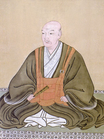
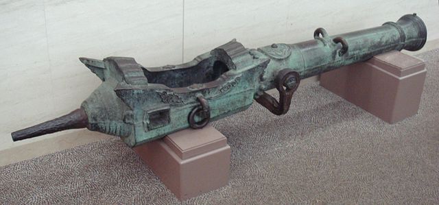
この想定は1586年に南九州から島津氏が大友氏の領地に侵攻したときに現実となりました。宗麟は、天下人の豊臣秀吉に救援を求めましたが、島津氏は秀吉からの援軍が到着する前に全九州地方を征服しようとしました。島津の軍勢はこの城を取り囲み、大友は運命は風前の灯のようでした。そのとき、大友方の最終兵器として「国崩し」との異名を持ち、ポルトガルから輸入されたフランキ砲が火を噴き、島津を駆逐したと言われています。大友は滅亡を免れました。島津は城の攻略をあきらめて撤退し、最後は秀吉に降伏をしました。大友もまた苦難を避けられず、宗麟の子息、義統は後に秀吉により改易されました。
The assumption came true when Shimadu clan’s invasion from the south Kyushu assaulted Otomo’s territory in 1586. Sorin asked the ruler Hideyoshi Toyotomi for help, but Shimadu tried to conquer all of Kyushu region before the reinforcements from Toyotomi arrived. Shimadu’s troops surrounded the castle while Otomo was like a candle flickering in the wind. However, it is said that Otomo’s ultimate weapon, Breech-loading swivel gun imported from Portugal, nicknamed “Destroyer of nations”, eliminated Simadu before Otomo escaped death. Shimadu gave up to capture the castle, withdrew, and surrendered to Toyotomi in the end. Otomo were also not without trouble, because Sorin’s son, Yoshimune was fired later by Toyotomi.

島津軍を率いた島津義弘肖像画、尚古集成館蔵~The portrait of Yoshihiro Shimasu, the head of the Shimadu troop, owned by Shoko Shuseikan Museum(licensed under Public Domain via Wikipedia Commons)

江戸時代には、この城は臼杵藩の所有となり、主に「臼杵城」と呼ばれるようになりました。城の範囲は島の外に広がり、便益のために「大手門」や「三の丸」が設置されました。
In the Edo Period, the castle was in the Usuki Domain, mainly called “Usuki Castle”. Its range spread outside the island setting the main gate “Otemon” and the third enclosure “Sannomaru” for convenience.

「豊後之内臼杵城絵図」部分、江戸時代~Part of the illustration of Usuki Castle in Bungo Province, in the Edo Period(出典:国立公文書館)

特徴~Features

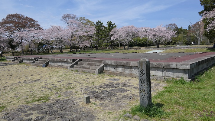
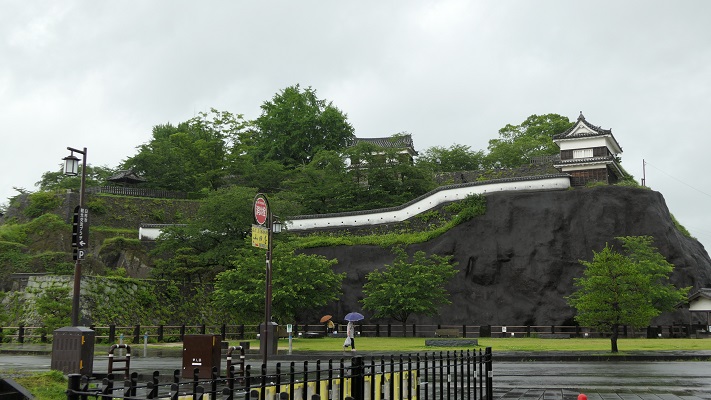
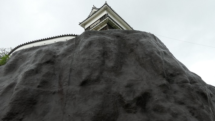
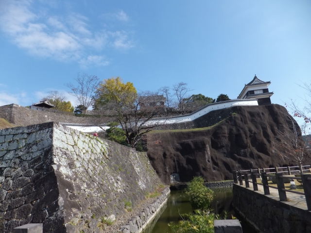
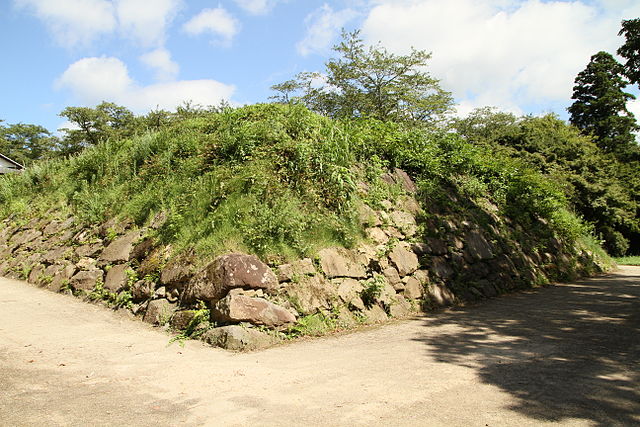
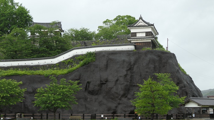
臼杵城は「臼杵公園」となっています。公園は今では完全に陸地の一部になっていますが、以前は島だったというのがその形からわかります。なぜなら今では島の代わりに岩山のように見えるからです。
The ruins of Usuki Castle has become “the Usuki Park”. The park is now completely part of land, but you can see the shape of the former island. Because it looks like a rocky hill instead of an island.

城周辺の地図~The normal map around the castle

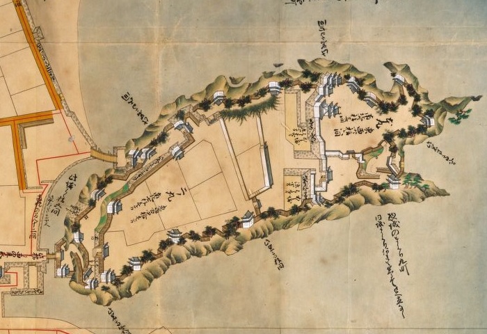
城周辺の航空写真~The aerial photo around the castle

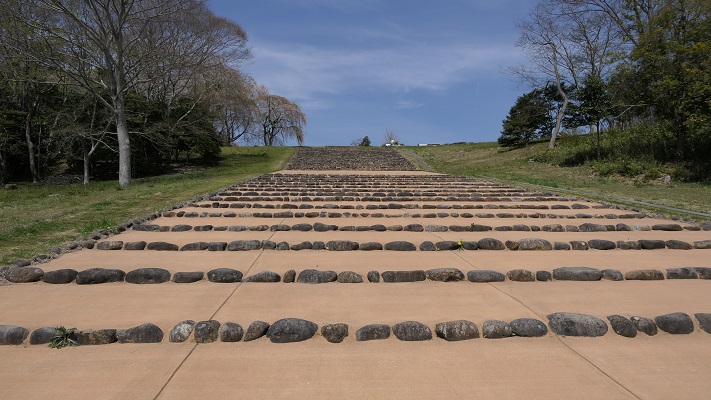
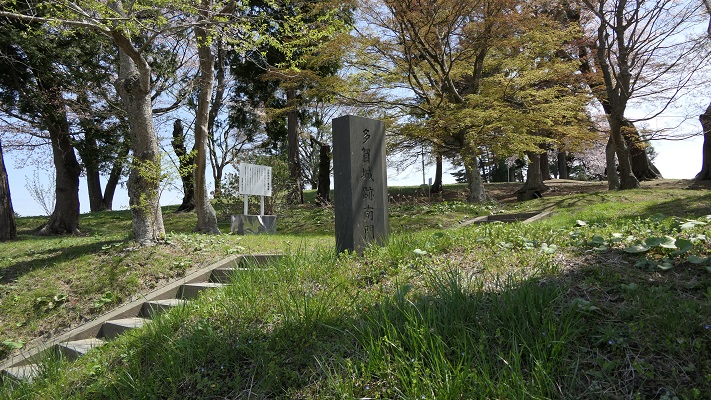
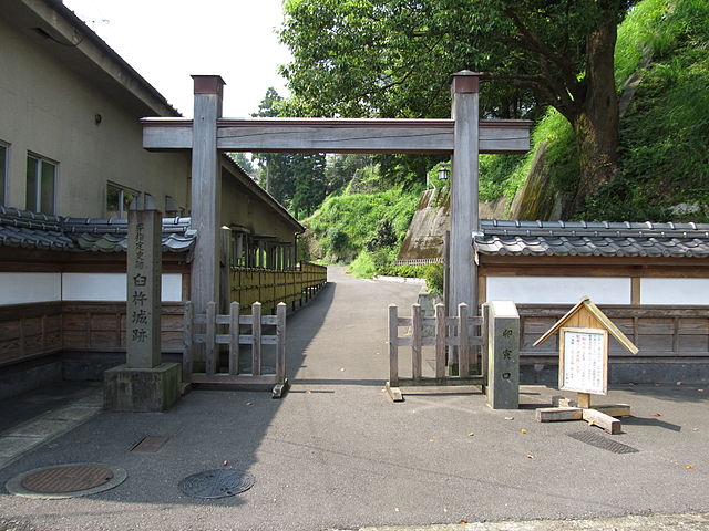
最初は正面口である「古橋口」から登ってみましょう。この入り口は大友時代から存在し、二の丸に通じています。この城は部分的に石垣に覆われ、2つの現存櫓といくつか復元建築物もあるのですが、元は江戸時代に作られたものです。
You can first climb up narrow stairs from the front entrance called “Furuhashi-Guchi”, which has existed from Otomo era, to the second enclosure “Ninomaru”. The castle has been partly covered with stone walls, and had two remaining turrets and some recently restored buildings. Their origin goes back to the Edo Period.

古橋口~The Furuhashi-Guchi(licensed by Twilight2640 via Wikipedia Commons)
臼杵城の石垣、塀、現存櫓「畳櫓」~The stone walls, plaster walls, and one of the remaining turrets “Tatami-Yagura” of Usuki Castle(taken by おさむし from photoAC)

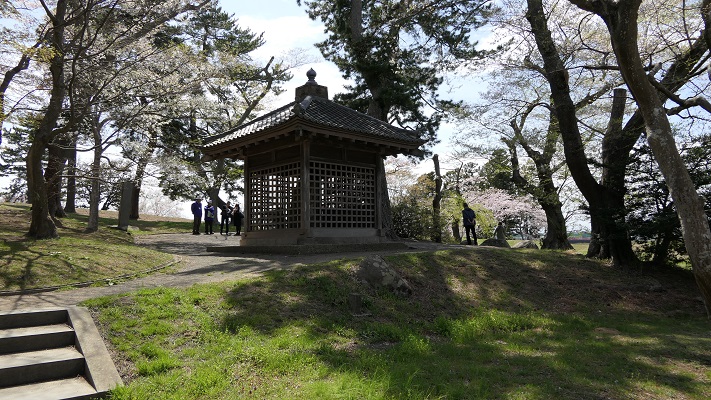
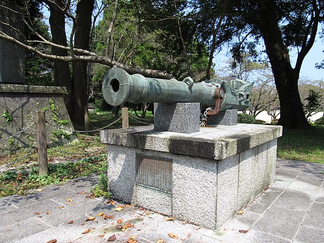
二の丸はこの島の一番高いところにあり、領主のための館が城の歴史の最初と後半の時期に設けられました。ここにはフランキ砲のレプリカがあります。また余談ですが、丹生島城の戦いで使われた本物の大砲は、東京の靖国神社にある遊就館に展示されています。
Ninomaru was the highest point of the island where the halls for the masters were in the first and the last of the castle’s life. You can see the replica of a breech-loading swivel gun at this spot. In addition, you can also see the genuine gun which was used in the Battle of Niu Island Castle in the Yushukan Museum of Yasukuni Shrine, Tokyo.

二の丸にあるフランキ砲のレプリカ~The replica of a breech-loading swivel gun at Ninomaru(licensed by Twilight2640 via Wikipedia Commons)
遊就館にあるフランキ砲~The breech-loading swivel gun at Yushukan Museum(licensed by Uploadalt via Wikipedia Commons)

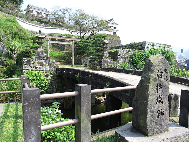
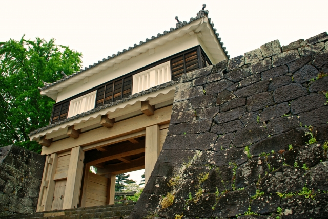
島の後ろ側には本丸があり、江戸初期に天守が建築されました。ここは一時期城の中心地とされたのですが、長くは使われませんでした。恐らく二の丸より低く狭かったからでしょう。「卯寅口」と呼ばれる通用口は、本丸から下って船着き場に通じており、非常時を考え作られました。その外側は今は海ではないですが、この出入口にはまだ船着き場の雰囲気が残っています。
The back side of the island was the main enclosure “Honmaru” where the Tenshu keep was built in the early Edo Period. This place was once set as the center of the castle, but it wasn’t used for long, perhaps because of being lower and smaller than Ninomaru. The back entrance called “Uto-no-Kuchi” goes down from Honmaru to the port for emergency. Though outside is now not the sea, the entrance still has an atmosphere of a port.

本丸にある天守台の石垣~The stone walls for Tenshu at Honmaru(licensed by 小池隆 via Wikipedia Commons
卯寅口~The Uto-no-Guchi(licensed by Twilight2640 via Wikipedia Commons)

その後~Later Life

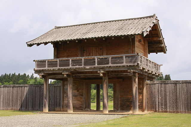
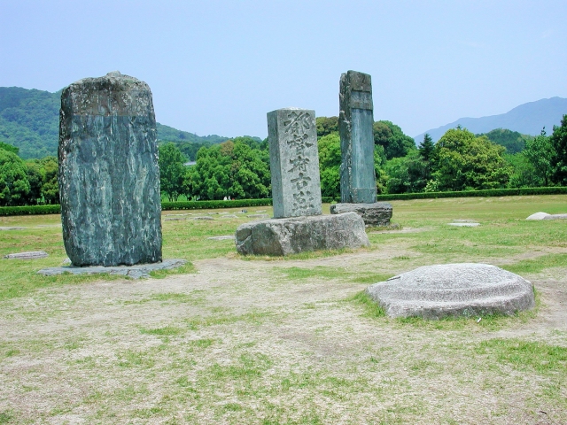
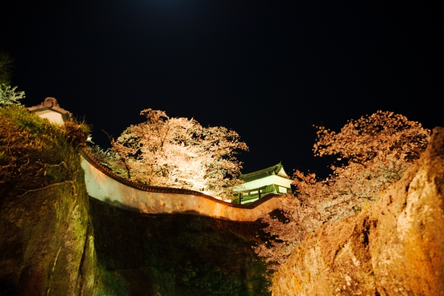
明治維新後、この城は公園となりました。天守や他の多くの櫓は廃材として売られるか、自然に崩壊しました。公園は有名になりましたが、桜の名所としてであって史跡としてではありませんでした。例を挙げると、天守台の高石垣が残っていたのですが、景観上の理由で削られてしまいました。最終的には1966年に城跡が県の史跡として指定されました。最近には2001年に「大門櫓」という櫓門が木造で復元されました。
After the Meiji Restoration, the castle was turned into a park. The Tenshu keep and many other turrets were sold as waste materials, or collapsed naturally. The park became famous for cherry blossoms, but not for being a historic site. For example, the remaining high stone walls for Tenshu was filed for landscape. Lastly, the ruins were designated as a prefectural historic site in 1966. Recently, a turret gate called “Daimon-Yagura” was restored in wooden style in 2001.

臼杵城の夜桜~The cxherry blossoms at night in Usuki Castle(taken by seama2 from photoAC)
復元された大門櫓~The restored Daimon-Yagura(licensed by チャコ via Wikipedia Commons)

私の感想~My Impression

臼杵城周辺の地域は、城と同じように岩山に囲まれ、石垣を使った建物も見られます。市街地も見て回られてはいかがでしょうか。また臼杵市は、「臼杵石仏」でも有名です。市街地から約5km離れた所にあります。
The area around Usuki Castle is surrounded by rocky hills and some buildings there use stone walls like the castle. Why not get around the city area as well. Uski City is also famous for “Uski Stone Buddha”, away from about 5 km from the city area.

岩山の上の臼杵城~Usuki Castle on the rocky hill

ここに行くには~How to get There

JR臼杵駅から歩いて古橋口は約15分、卯寅口には約10分かかります。
大分空港から臼杵駅まで:
大分駅行き空港アクセスバス(エアライナー)に乗り、大分駅でJR日豊本線に乗り換えてください。
もしくは、佐伯駅行き空港バスに乗り、臼杵インターチェンジバス停で降り、近くの白馬渓バス停まで歩き、佐伯駅まで大分バスに乗ってください。
It takes about 15 minutes to get Furuhashi-Guchi, or about 10 minutes to get Uto-no-Guchi on foot from the JR Usuki station.
From Oita Airport to Uusiki st.:
Take the Airpor Eepress Airliner bus to Oita station, and transfer at the station for JR Nippo line.
Or take the Express Limousine Bus to Saiki station, get off at Usuki Interchange bus stop, walk to Hakubakei bus stop nearby, and take the Oita bus to Usuki station.

リンク、参考情報~Links and Referencec

臼杵観光情報協会~Usuki-City Tourist Information Organization
・大友の聖将、赤神諒、角川春樹事務所(Japanese Book)
・よみがえる日本の城20、学習研究社(Japanese Magazine)

7.多賀城(Taga-Jo)

多賀城政庁跡(The ruins of Taga-Jo government district)

Location and History

多賀城は、「城柵」と呼ばれた政府の事業拠点の代表的なものです。城柵は、古代に朝廷が東北地方を支配するために設置されました。当時北東北には、「蝦夷」と呼ばれた朝廷に服さない人たちがもともと住んでいました。蝦夷は、朝廷の支配下にあった古代日本人とは違う言語を話し、その一部はまたアイヌ民族の先祖になったと言われています。
Taga-jo was one of the representatives of official defense sites called “Josaku” which were placed for the governance of Tohoku district by the central government in the Ancient Ages. Originally, people called “Emishi”, who were not subject to the government, lived in the north of Tohoku at that time. They spoke a different language from the ancient Japanese under the government, and part of them were also said to be ancestors of the Ainu tribe.

復元された他の城柵(払田柵)の門(The restored gate of another Josaku called Hottanosaku)licensed by 小池隆 via Wikimedeia Commons

朝廷は領域拡大を図るため、東北に領民を移住させたり、「蝦夷」の人たちをも臣民として定住させたりしました。しかし、蝦夷はしばしば朝廷に反乱を起こしました。城柵は、城としての機能だけでなく、政庁や居住としての機能をもった複合施設でした。多賀城は、主要な城柵の一つであり、朝廷と蝦夷との境界近くに設置されたのです。
The government aimed to spread its domain, so it tried to relocate people there, and to accommodate “Emishi” people as its subjects. However, Emishi often rebelled against the government. Josaku were complex sites not only for castles, but also for government districts and resident facilities. Taga-jo was the primary site among the other Josaku which was near the border between territories of the government and Emishi people.

多賀城と8世紀の主な城柵の位置(The map of Taga-Jo and other major Josaku in the 8 century)


724年の設立から9世紀くらいまでに、多賀城は3回作り直されました。その間、まず762年に大改修後、780年に蝦夷の襲撃を受け、869年には貞観地震の被害を受けました。その後、通常は国府として使われたのですが、必要なときには軍事拠点として活用されました。そして1337年に、南朝の陸奥将軍府が他の地に移転したとき、ついに多賀城の歴史は終わったのです。
From its creation in 724 to around the 9th century, Taga-jo was rebuilt three times. During that time, it was renovated in 762, suffered from the attack of Emishi in 780 and the 869 Sanriku Earthquake. After that, the site was usually used as a provincial capital, but sometimes used as a military base when necessary. When the General’s Outpost in Mutsu by the Southern Court at this site was moved to another in 1337, the history of Taga-jo ended at last.

政庁跡の後ろ側(The back side of the gevornment district ruins)

Features

多賀城跡は、現在主に2つの部分からなります。一つは政庁跡であり、丘の上に施設の中心として存在していました。そこには建物や柱の基礎がアスファルトに覆われた形で残っています。
The ruins of Taga-jo now mainly consist of two parts. One of them is the ruin of the government district which was the center of the site on a hill. It has a lot of foundations of buildings and columns covered with asphalt.

建物や柱の基礎跡(The ruins of foundations of buildings and columns)

よって、過去にはその場所がどのような姿だったのか想像することができます。そして、そこから多賀城の外郭南門に通じる大きな道がつながっています。
So you can see and imagine how the site was in the past. There is a large road which goes down to the ruins of the south gate of the outer wall.

現地には政庁のミニチュア模型もあります。(There is also a miniature model at the site)
政庁前の大道(The large road in front of the government district)

もう一つは多賀城碑で、多賀城の歴史の一端を語るものです。それは表面に文字が刻まれた石碑であり、762年の大改修が完成したのを記念して作られたと書かれています。
The other is the Taga-jo Monument which describes part of Taga-jo’s history. It is made of stone with letters engraved on it. It says that it was made due to the first renovation being completed in 762.

多賀城碑(The Taga-Jo Monument)licensed by Saigen Jiro via Wikimedia Commons

この碑は、江戸時代初期に南門跡周辺で発見され、その当時からその地で覆堂に収納されています。石碑は扉越しに見学することができます。また、近くにある東北歴史博物館では、そのレプリカも見ることができます。
It is found around the south gate ruins in the first Edo period, and contains a sheath house there from that time period. You can see the monument through the door of the house, and can also see the replica of it at the Tohoku History Museum nearby.

南門跡(The ruins of the south gate)
石碑が入っている覆堂(The sheath house including the monument)

Later Life

多賀城跡は、石碑により江戸時代から全国に知られていました。しかしながら、歴史家の中には、いくつかの疑念から石碑は偽物ではないかと言っている人もいます。それは遺跡にとっては重大問題であり、なぜならこの石碑はこの遺跡が「多賀城」と呼ばれるための唯一の確かな証拠とされているからです。
The Taga-jo ruins have been known around the whole country for the monument since the Edo period. However some historians say the monument might be a fake and have some questions. That was a big problem for the ruins, because the monument is supposed to be the only certain proof that can call the ruins “Taga-jo”.

多賀城碑碑文、安井息軒「読書余滴」より(The copy of Taga-Jo Monument from “Dokusho-Yoteki” by Sokuken Yasui)licensed under Public Domain via Wikimedia Commons

第二次世界大戦後、遺跡の主要な部分が発掘されました。その結果はおおむね石碑に書かれていることと一致しました。現在の定説ではこの石碑は本物とされています。発掘の成果をもって、遺跡は1966年に国の特別史跡に指定されました。
After World War II, the primary areas of the ruins were excavated. The results mostly match what is written on the monument, now the established theory says it is genuine. With the achievement of the excavation, the ruins were designated as a national special historic site in 1966.

My Impression

多賀城の政庁跡は、九州の大宰府政庁跡によく似ています。そのイメージは、私たちが普段想像するところの城とは異なりますが、多賀城は古代の城として様々な側面を持っていたのです。
今(2019年)から数年後に外郭南門が復元されるそうです。そのときにまた多賀城を訪れてみようと思います。
The ruins of the government district looks like that of Dazai-fu government district in Kyushu. It doesn’t look like our simplest understanding of what a castle is. But Taga-jo had many perspectives which was a style of ancient castles.
I have heard that the south gate of the outer wall will be restored several years from now (2019). I hope to visit Taga-jo again then.

九州の大宰府政庁跡(The ruins of Dazaifu government district in Kyushu)taken by エルドン from photo AC

How to get There

JR国府多賀城駅から歩いて10~15分程です。駅の近くに東北歴史博物館がありますので、是非一緒に訪れてみてください。
東京から国府多賀城駅まで:東北新幹線に乗って仙台駅まで行き、東北本線に乗り換えてください。
It takes about 10 to 15 minutes on foot from the JR Kokufu-Tagajo station. It is a good idea to visit the Tohoku History Museum just near the station as well.
From Tokyo to the station: Take the Tohoku Shinkansen super express to Sendai st., and transfer to the Tohoku Line.

Links and Refferences

多賀城市観光協会(Tagajo Tourism Organization)
・「蝦夷と城柵の時代」熊谷公男編、吉川弘文館(Japanese Book)