8.仙台城(Sendai Castle)

本丸の伊達政宗像(The statue of Masamune Date at Honmaru area)

Location and History

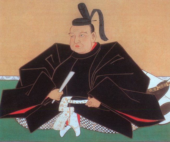
仙台は日本の東北地方で最大の都市であるとともに、宮城県の県庁所在地でもあります。仙台の歴史は、仙台城と共に始まりました。この城の創始者、伊達政宗は若く偉大な戦国大名だったのですが、徳川幕府が天下を制してからは従わざるをえませんでした。仙台城は、正宗が居住する城として、3つの候補地から将軍徳川家康によって選ばれたと言われています。
Sendai is the biggest city in Tohoku district of Japan, and the prefectural capital of Miyagi pref. The city started its history with the Sendai castle. The founder of the castle, Masamune Date was a great young warlord, but he had to follow the Tokugawa Shogunate after its unification of the whole country. It is said the Sendai castle was designated for Date to settle from three options by the shogun Ieyasu Tokugawa.

伊達政宗像、仙台市博物館蔵(The picture of Masamune Date owned by Sendai City Museum)licensed under Public Domain via Wikimedia Commons

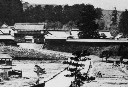
実のところ、戦乱が終息した当時において、新しい城を平地ではなく山の上に設置するというのは大変稀なことだったのです。その中でも本丸エリアの防御力は特に強力でした。本丸の東側は垂直の崖であり、南は川の渓谷に、西は深い山になっていました。北側だけがアクセス可能でしたが、多くの構造物や仕掛けにより敵の攻撃から守られていました。なぜ家康が正宗にこのような強力な城を作らせたのか、明確な理由はわかっていません。
Actually, it was very rare for a new castle to be on a mountain area instead of a plain area at that time when the war was over. The main enclosure “Honmaru” area was strong defensively. Its east side had a vertical cliff, south was a river valley, and west was a deep mountain. Only the north side was accessible, but many structures and devices were set on this side to prevent enemies from attacking. No one can clearly explain why Tokugawa let Date build the strong castle.

城周辺の段彩陰影図(The transparent color shaded relief map around the castle)


というのも、幕府は通常、大名が強力な陣地に立てこもって反乱を起こすようなことは望まないからです。結果的には、仙台藩の2代目藩主は平地である二の丸に移っていきました。そこに二の丸御殿を築いてからは、居住するにも政治を行うにも便利になりました。
Because the shogunate usually didn’t want to have lords get labeled based on a strong site, eventually, the second generation of the feudal domain of Sendai moved to the plain area called “Ninomaru”. After the construction of the Ninomaru main hall, they were able to live and govern conveniently.

二の丸の古写真(An old picture of Ninomaru)licensed by katana 213 via Wikimedia Commons

Features

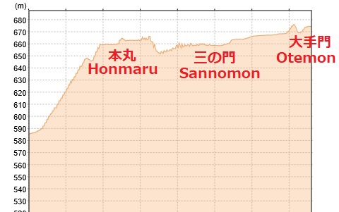
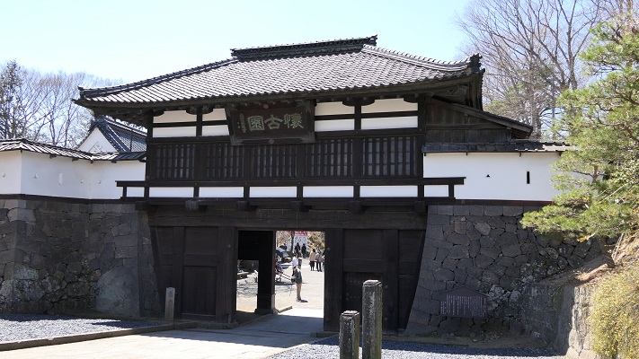
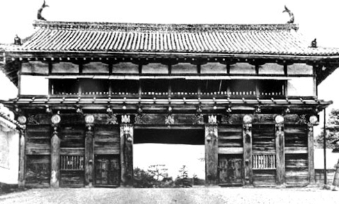
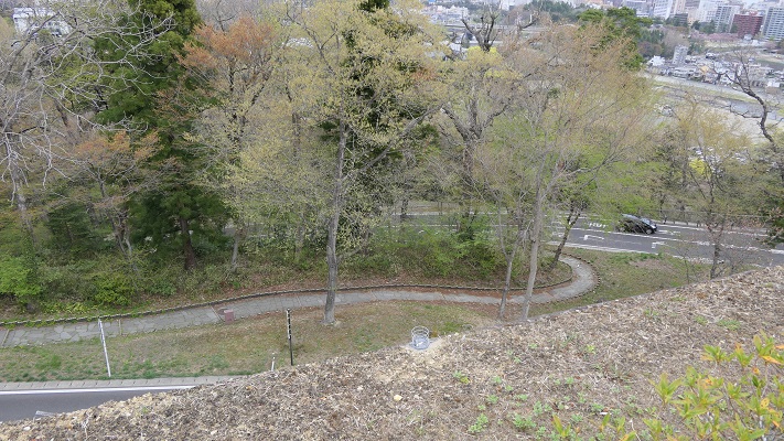
それでは、本丸エリアの北側を歩いて登ってみましょう。最初に大手門跡に立ってみます。そこには特大の門があったのですが、1945年の仙台空襲により焼失してしまいました。現在では、戦後に再建された大手門の脇櫓だけを見ることができます。
Let’s walk up the north side of the Honmaru area. At first, you can try standing on the ruin of the main entrance “Otemon” where a very large scale gate building was located until it was burned down by the Sendai air raid in 1945. The side turret building of the Otemon we can see now was rebuilt after the war.

大手門跡(The ruin of Otemon)
大手門の古写真、1938年(An old picture of Otemon in 1938)licensed under Public Domain via Wikimedia Commons
再建された大手門脇櫓(The rebuilt side turret of Otemon)

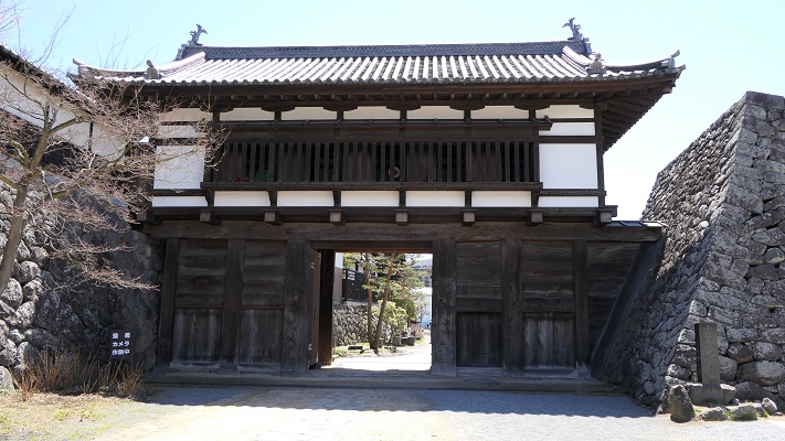
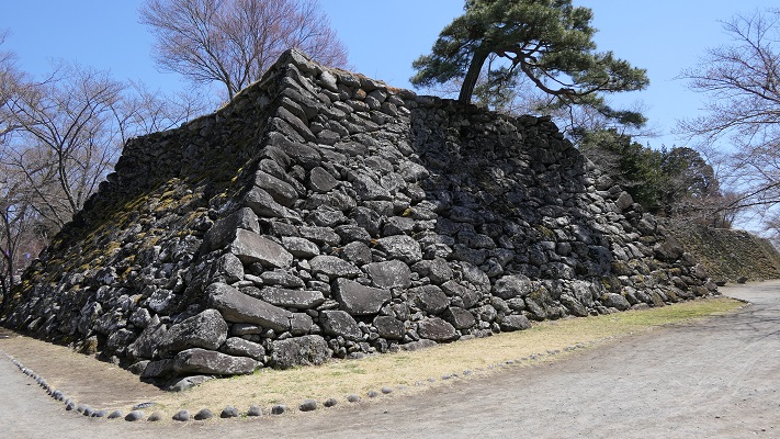
そこから本丸に向かっていくには、急で曲がりくねった道を登っていき、もう一つの門「中の門」を通り過ぎなければなりません。その後、行く手を遮るような高く広い本丸石垣が立ちはだかっているのにびっくりするかもしれません。
Then, you have to climb up a steep and winding road with passing through the ruin of another gate called “Nakanomon” to head towards Honmaru. After that, you may be surprised to see the tall and wide stone walls of Honmaru stand in your way.

中の門跡(The ruin of Nakanomon)
本丸北石垣(The north stone walls of Honmaru)

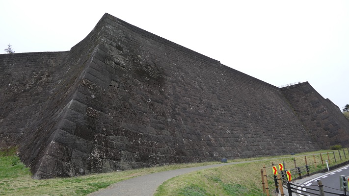
過去にはこの石垣の上には、3基の3階櫓が建っていて、攻撃側を迎え撃てるようにしていました。ついには、最後の門である「詰の門」から入れば本丸に到着します。
In the past, three of three story turrets were on the stone walls that would be tough for attackers. Finally, entering the last gate “Tsumenomon”, you will reach Honmaru.

詰の門跡(The ruin of Tsumenomon)
本丸御殿跡(The ruin of Honmaru main hall)
本丸北石垣から見下ろした眺め(A view looking down from the north stone walls of Honmaru

本丸北側の地図(The map of north side of Honmaru)
(マーカーをクリックして地点の名前を確認してください。)
(Please click a marker, and check the name of the point.)


Later Life

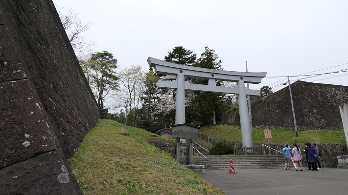
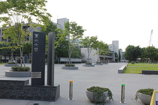
明治維新後、日本陸軍の第2師団が司令部をこの城に置き、その時に元あった建物の大半は撤去されてしまいました。第二次世界大戦後は、米軍がこの地区に駐留していました。日本の独立回復後は、本丸地区は仙台市と護国神社が分け合い、二の丸地区は東北大学が使用しています。行政は今、発掘の成果に基づき、どうやって城跡を整備していけるのか慎重に検討しています。
After the Meiji restoration, the headquarters of the Japanese army 2nd division was located in the castle with most of original buildings being demolished. After the World War II, the US army occupied the area then. After the restoration of sovereignty, the Honmaru area is divided by Sendai city and the Gokoku shrine, and the Ninomaru area is used for the Touhoku University. Officials are now considering how they can improve the castle ruins carefully with the achievement of excavations.

二の丸地区にある東北大学(Tohoku University on Ninomaru area)licensed by XIIIfromTOKYO via Wikimedia Commons

My impression

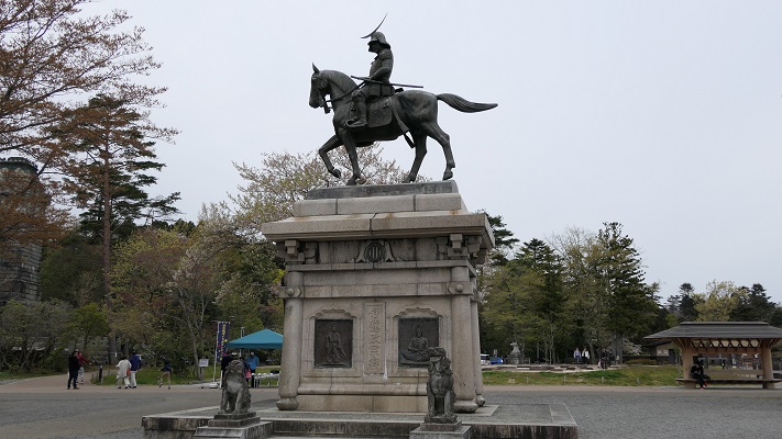
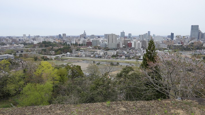
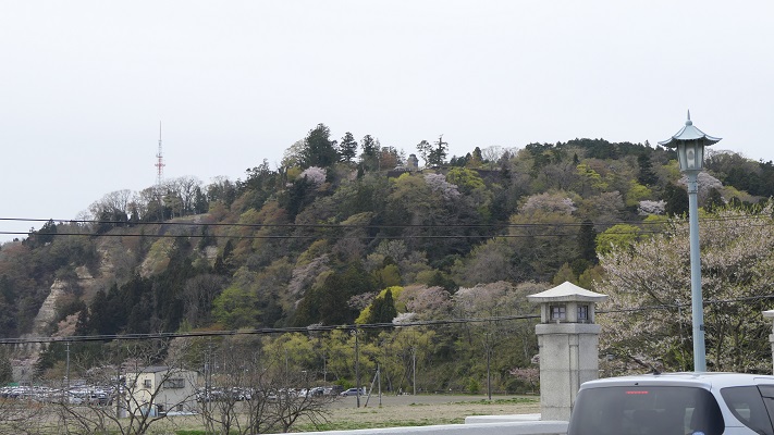
今現在、仙台駅からバスや車を使って本丸地区に行くのはとても簡単です。そこでは、素晴らしい景色や伊達政宗の銅像を見ることができます。でも、当方としてはそれだけでは仙台の町や城を知るには不十分だと思います。1時間程かかりますが、仙台駅から城跡まで歩いてみてはいかがでしょう。
Now, it is very easy for anyone to access the Honmaru area from the Sendai station by bus or car, there you can see the great view and the bronze statue of Date. But I think that is not enough to know about the Sendai town and castle. I recommend walking from the station to the castle ruins of about one hour.

本丸地区からの仙台の街並み(A view of Sendai town from Honmaru area)

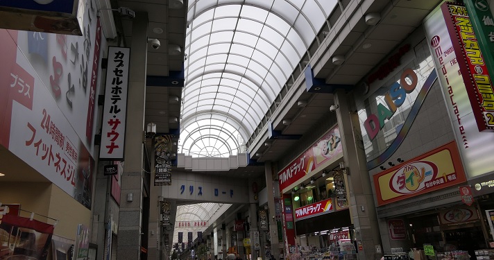
仙台駅の北側にあるパルコ・ビルディングの反対側から始まるクリスロードをまっすぐ進んでください。この通りは何百件もの店舗からなるアーケードになっていて、買い物も楽しむことができます。
Go straight to the Clisroad which starts from the opposite side of the Parco building near north side of the station. The road is an arcade with hundreds of shops, you can also enjoy shopping there.

クリスロード(The Crisroad)

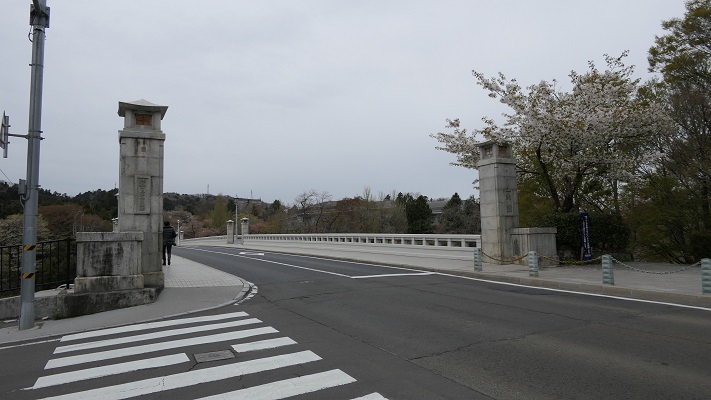
そのまま進むと、広瀬川にかかる大橋に着きます。そこを渡れば大手門跡に到着です。参考として、城跡の近くにある地下鉄東西線の国際センター駅から歩くこともできます。
It will lead you to the Ohashi Bridge across the Hirose River. You will reach the ruin of Otemon. In addition, you can also walk from the International Center station on the Tozai subway line near the ruin.

大橋(The Ohashi bridge)
大橋から見た本丸地区(A view of Honmaru area from Ohashi bridge)

赤い線がお勧めルートです(The red line shows the recommended route)


How to get There

仙台駅からバスで行きたい場合:西口バス乗り場から出ているループル仙台バスに乗ってください。(ピーク時には15~20分毎)
国際センター駅から歩きたい場合:仙台駅から地下鉄東西線に乗り換えてください。
東京から仙台駅まで:東北新幹線に乗ってください。
If you want to go there by bus from Sendai station: Take the Loople-Sendai bus that comes every 15 or 20 minutes at the top of the hour at the west entrance bus pool.
If you wish to walk there from the International Center station: Take the Tozai subway line from the Sendai station.
From Tokyo to Sendai st.: Take the Tohoku Shinkansen super express.

28.小諸城(Komoro Castle)

Location and History

小諸城は少し変なところにありました。この城は、かつての小諸宿、現在の小諸市の中心部のすぐ近くに位置していました。基本的に城というのは周りの土地より高いところに作られました。なぜならその方が守備側から攻めやすく且つ守りやすいからです。また、町の人々に権威を見せつけることもできます。しかしながら、この城は町より低いところにありました。城の中心部に行けば行くほど低くなっていくのです。そんなわけでこの城は「穴城」とも呼ばれています。そんな立地の理由は恐らく城の地形にあるのでしょう。城は、急崖と深い溝を伴った河岸段丘の端にあります。町の反対側から攻めるのは難しすぎます。城の築城者は、利点と不利な点を勘案し妥協したのではないでしょうか。

最新の城周辺の地図(The latest map around the castle)


The Komoro Castle had a little strange location. The castle was located just near the Komoro traditional post town, now at the center of the Komoro city. Basically, castles were set on higher places than surrounding areas because that way defenders easily attack and protect against enemies. It can also show authority to people. However, this castle was lower than the town. The more one approaches the center of the castle, the lower the altitude is. So the castle is also called “the hole castle”, “Anajo”. The reason for such a location would be the terrain of the castle. It is at the edge of a river terrace with steep cliffs and ditches. It is too difficult to charge from the opposite side of town. The founder of the castle seemed to compromise between its advantages and a disadvantage.

小諸城の土地の断面図(The cross section of Komoro castle’s ground)

小諸城は最初は15世紀に建てられたと言われています。戦国時代には、武田氏が周辺の地域を支配しました。江戸時代の初期には城主であった仙石氏がこの城を完成させました。防衛の必要性からこの城は町の方向に曲輪を広げていったのです。そして主な曲輪の入り口には、大きく堅固な門がありました。その内の2つの門が現在残っていますが(「三の門」と「大手門」)、他の門は撤去されました。両方とも重要文化財に指定されています。

三の門(Sannomon)

It is said that Komoro Castle was first built in the 15th century. In the civil war period, the Takeda clan governed the area around it. At the beginning of the Edo era, the lord of the Sengoku clan completed the castle. Because of the need for defense, the castle had spread enclosures around the town. The major enclosures had large and well constructed entrance gates. Two of these gates remain now (“the third gate” “Sannomon” and “the main gate” “Otemon”), but the others were demolished. Both are designated as the important cultural properties.

大手門の内側(The inside of Otemon)

Features

城の主要部分は現在、「懐古園」の名で公園として使われています。ここでは桜園、博物館、動物園、そして城跡と見所がたくさんあります。三の門は今、懐古園の正面入り口として使われており、公園の名前が書かれた額と共に移っている写真で日頃から有名です。
The main area of the castle has now been turned into the public park, “Kaikoen”. It offers many attractions like cherry blossoms, museums, a zoo, as well as the ruins of the castle. The Sannomon gate is now used as the main gate of Kaikoen which is usually famous for pictures with the park name tablet.

「懐古園」の額と三の門(The tablet of “Kaikoen” and the Sannomon)

いろいろ楽しんだ後、公園の端の方に行ってみると、少々驚かれるかもしれません。そこは高い崖に囲われていて、周辺一帯の見事な景色を見ることができるのです。そう感じるのは、小諸城の独特の構造によるものなのでしょう。
After enjoying these attractions, when you reach the edge of the park, you might be surprised that the park has a great view of the area around it with high cliffs. That’s because of the structure of Komoro Castle.

城の端地点からの景色(A view from the edge of the castle)

大手門は現在、公園の反対側の方にあります。明治時代に鉄道が城の中を通って、隔てられてしまったからです。この門は一時民間に売却されて、料亭や塾の建物として使われていました。最近になって行政が買い戻して、元の外観に戻す復元工事を行い、今は一般に公開されています。
The Otemon gate is now on the opposite side of the park, as the train line divided the castle in the Meiji era. The gate was once sold to the private sector, and used as a traditional Japanese restaurant or a private school. Recently, officials bought it back, restored it to its original appearance, and now open to the public.

大手門の外側(The outside of Otemon)

(’19-9-5 追記 added)
なお、城には天守が今も残っている天守台の上にありましたが、1626年に落雷により焼け落ちてしまいました。
In addition, the castle had the keep “Tenshu” on the now remaining base of Tenshu. But it was burned down by a stroke of lightning in 1626.

現存する天守台(The remaining base of Tenshu)

Later Life

江戸時代が終わったとき、城は廃城となりましたが、小諸藩士の多くがこの城の行く末を憂えました。彼らは資金を集め、城の主要部分を買い取ることができました。そして、そこを「懐古園」と名付け、懐古神社を設立したのです。現在の持ち主(藩士の子孫たち)は、市に公園として貸しているとのことです。

本丸にある懐古神社(The Kaiko shrine at Honmaru area)

When the Edo Period ended. The castle was closed, many of warriors worried about the future of the castle. They collected money and were successful to buy the main area of the castle. They named it “Kaikoen” and established the Kaiko shrine. Now the owners (descendants of the warriors) lend the area to officials as the park.

My Inpression

私も最初はこの城跡は古門や石垣を除いては普通の公園のようだと感じたのです。しかし、奥に歩いていくにつれて、なぜ築城者がここに城を作ったのかわかった気がしました。
At first, I felt that the ruins were just like a park except for the old gates and remaining stone walls. But I walked to the edge of them, and I was able to understand why the founder built the castle there.

自然の地形を生かした堀切(The ditch using natural terrain)

地理に興味がある方は、城の周りを見て歩くのもいいかもしれません。典型的な河岸段丘とともに、高い崖に様々な地層を見ることができます。
For those who are interested in geography, it is a good idea to look around the area. You can see geological formations on the high cliffs with typical river terraces.

近くの崖に見られる地層(A geological formatioon on a cliff nearby)

How to get

ここに行くには電車がベストでしょう。なにしろ小諸駅が城の一部であった所にあるからです。車で行く場合には、懐古園に駐車場があります。
東京から小諸駅まで:北陸新幹線で軽井沢駅まで行き、しなの鉄道の普通列車に乗り換えてください。

It is best to use train to access it, as the Komoro train station was built on part of the castle area. When using a car, the Kaikoen park offers a parking lot.
From Tokyo to Komoro st.: Get the Hokuriku Shinkansen super express to Karuizawa st., and transfer to the Shinano Railway local line.

Links and References

こもろ観光局(The Komoro Tourism Bureau)