107.秋田城~Akita Castle

古代日本最北の城
The northernmost castle of ancient Japan

立地と歴史~Location and History

蝦夷と城柵~Emishi and Josaku

秋田城は、「城柵」と呼ばれた政府の防衛拠点の代表的なもの一つで、古代に中央政府により東北地方の統治のために設置されました。もともと東北地方には、政府の支配に属さない蝦夷と呼ばれる部族の人々が住んでいました。彼らは政府に属す古代の日本民族とは異なる言語を話し、またそのうちの一部はアイヌ民族の始祖になったと言われています。
Akita Castle was one of the representatives of official defense sites called “Josaku” and was placed for the governance of Tohoku Region by the central government in the Ancient Ages. Originally, people belonging to the Emishi tribe ,who were not subject of the government, lived in the north of Tohoku Region . They spoke a different language from that of the ancient Japanese people living under the government, and some of them were also said to be ancestors of the Ainu tribe.

蝦夷の頭領の一人、阿弖流為の出し物、青森ねぶた祭~The attraction of Aterui, one of the leaders of Emishi, in the Aomori Nebuta Festival (Photo by Aaron Cox from Pexels)

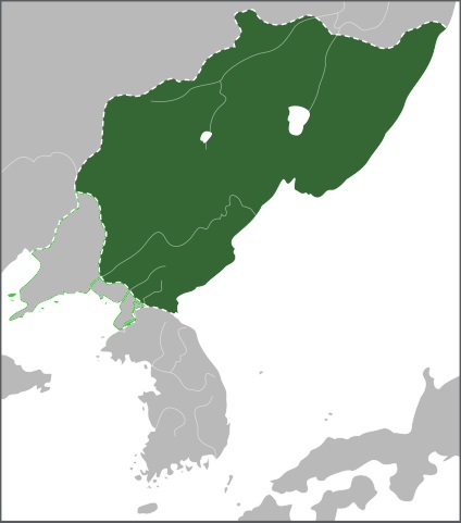
政府はその領土を広げるため、支配下の人々を移住させたり、「蝦夷」の人々を臣民として受け入れようとしました。ところが、蝦夷はしばしば政府に反抗しました。城柵は複合的な拠点で、城としての用途だけではなく、統治や全般的な用途の施設もありました。政府は10前後の城柵を築き、秋田城はそれらの中で最北で、出羽国の北部(現在の秋田県)に位置していました。
The government aimed to spread its domain, so it tried to relocate its own people there and to accommodate “Emishi” people as its subjects. However, Emishi often rebelled against the government. Josaku was a complex mix of sites made not only for the use of castles, but also for government purposes and general facilities. The government built around 10 Josaku and Akita Castle was the northernmost site among those Josaku and it was located on the northern part of Dewa Province (what is now known as Akita Prefecture).

主な城柵の位置~The locations of the main Josaku

最北の地で外交も~Even Diplomacy in Northmost land

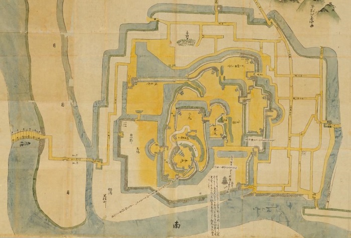
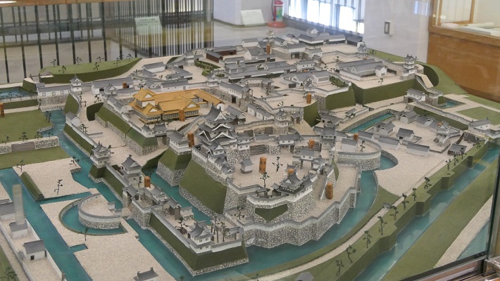
秋田城の起源は、733年に現在の山形県(秋田の南)から移転してきた「出羽柵」という城柵です。この移転は、領土拡大計画の一環でした。760年には秋田城と改称されます。この城は他の城柵と同じように、中心部分に政庁があり、外郭には高さ4mを超える屋根付きの築地塀が巡っており、外周は2km以上ありました。この拠点は出羽国の国府でもあり、アジア大陸にあった渤海国との外交を行う役目も担っていました。
The origin of Akita Castle lies in the Josaku called “Ideha-no-ki” which was moved in 733, from a region where now Yamagata Prefecture (south of Akita) is. This movement was done as a part of expansion plan. Then it was renamed Akita Castle in 760. The castle consisted of the Government Office in the center, and roofed mud walls on the outline, similar to other Josakus, which were over 4m high, and their perimeter was over 2km. The site was also the provincial capital of Dewa Province and had a role in the foreign diplomatic relation with Bohai Kingdom on the Asian continent.

政庁と外郭の範囲を示す現地の模型~The model which shows the ranges of the government office and the outline
渤海国の最大領土~The territory of Bohai Kingdom at its peak (licensed by Samhanin via Wikimedia Commons, partly modified)

多くの困難と遺産~Many difficulties and heritage

その期間中、秋田城は多くの災難に見舞われました。例えば830年には、出羽国大地震により大きな被害を受けました。その後、蝦夷の人々による2回の反乱が、878年と939年に起こりました。特に878年の元慶の乱では、城は一時占拠されてしまいます。発掘により、政庁が焼けた跡が実際に発見されました。
During its time, Akita castle faced a lot of adversities. For instance in 830, the castle suffered a heavy loss from the Dewa Great Earthquake. After that, two rebellions by Emishi people happened in 878 and 939 respectively. In particular, during the Gangyo Rebellion in 878, the castle was once captured. Traces of burned Government Office were actually found by the excavation.

現地にある政庁の模型~The model of the Government Office at the site (licensed by 掬茶 via Wikimedia Commons)

この城は10世紀にその歴史的役割を終えたため廃城となりました。しかしながら、城主の官職名「秋田城介」は武士の名誉職として使われ続けました。恐らくもともとの官職が北の地を鎮護するためのものだったからでしょう。
The castle was abandoned by the late 10th century after its historical reason was finished. However, the name of the castle’s lord “Akita-josuke” was used as a warrior’s honorary post, perhaps because the original post had been created for protectors of the northern lands.

安達泰盛、秋田城介で鎌倉幕府の重臣、「蒙古襲来絵詞」より~Yasumori Adachi, the Akita-Josuke and a senior vassal of the Kamakura Shogunate,  from “The picture scrolls of the Mongol invasion attempts against Japan” (licensed under Public Domain via Wikimedia Commons)

特徴~Features

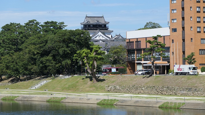
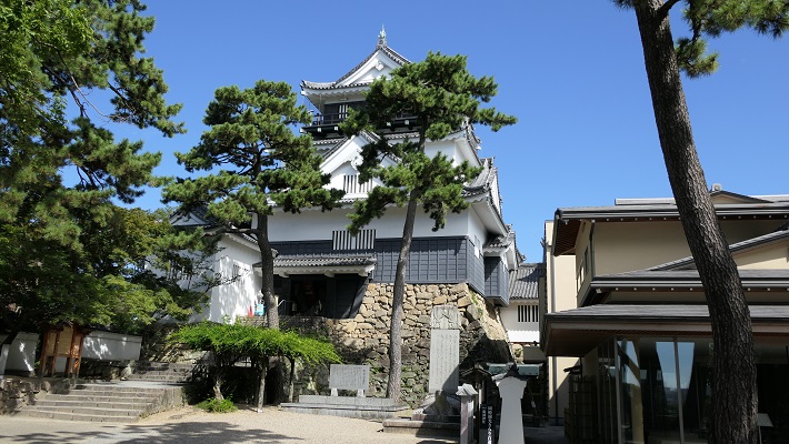
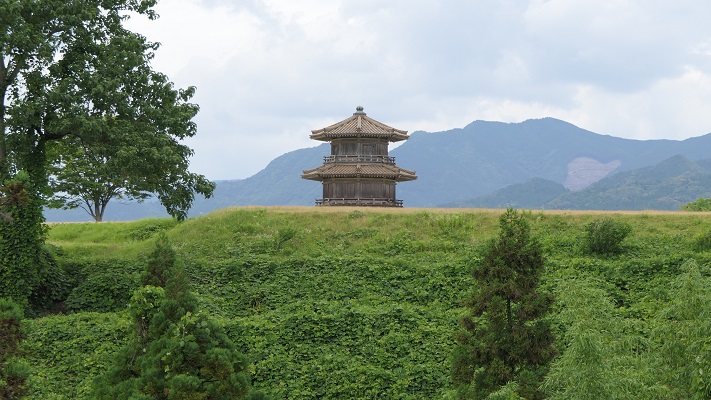
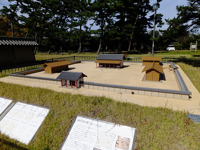
現在、秋田城跡は「高清水公園」という歴史公園として整備されています。更には最近の2016年、秋田城跡歴史資料館がオープンしました。公園でだけでなく、ここでも城について多くのことを学ぶことができます。公園には見ておくべき場所が三つあります。
Now, the ruins of Akita Castle have been developed as a historical park called “Takashimizu Park”. In addition, Akita City History Museum of Akita Fort Ruins opened recently in 2016. You can learn a lot about the castle at the museum as well as in the park. There are three main parts in the park you should check out.

城周辺の航空写真~The aerial photo around the castle

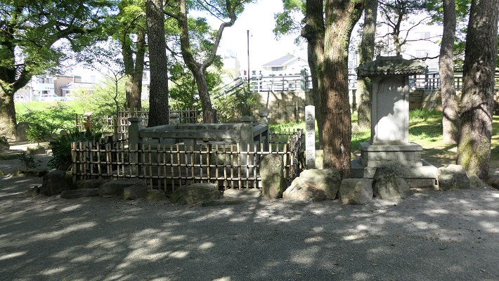
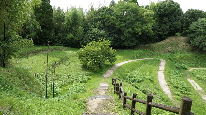
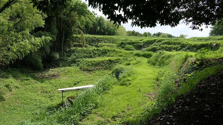
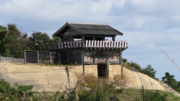
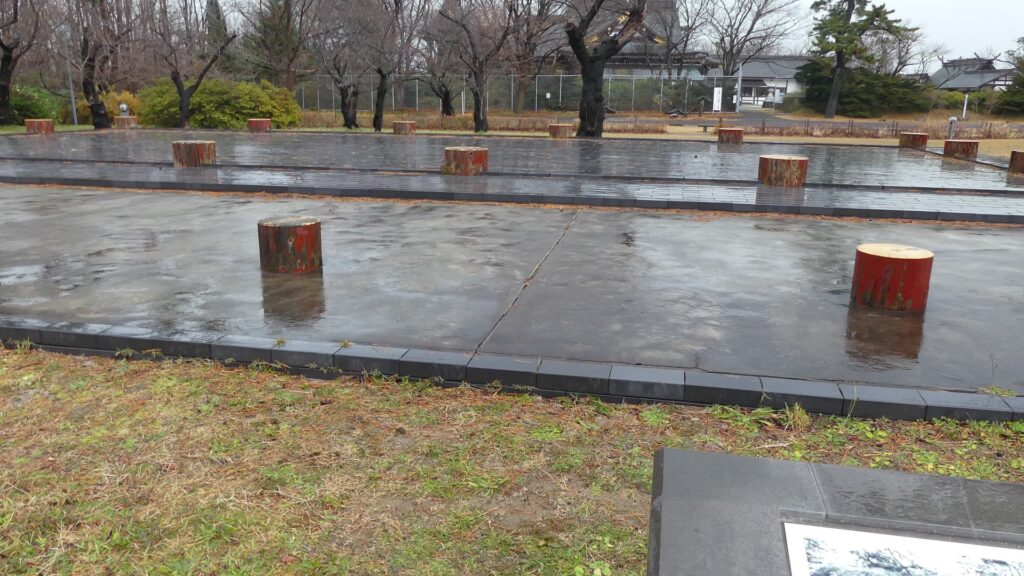
政庁跡~Ruins of Government Office

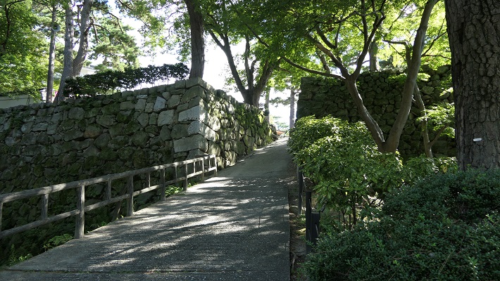
もし車かバスで公園を訪れた場合、駐車場かバス停からは一番近いところにあります。政庁もまた屋根付きの築地塀に囲まれていました。建物のレイアウトは、古代奈良にあった朝廷の建物に準じていました。城跡が発掘された後は、建物の柱の位置が地面の上にわかるようになっています。東門とともに塀の一部も復元されています。残念ながら、西側の部分は道路建設のために破壊されてしまいました。
If you visit the park by car or bus, it is the nearest spot from the parking lot or the bus stop. The government office was also surrounded by roofed mud walls. The layout of its buildings followed the way of the Imperial Palace in ancient Nara. After the ruins were excavated, the positions of the building columns can be seen on the ground. Part of the walls has also been restored with the Eastern Gate. Unfortunately, the western part was destroyed by the construction of the road.

政庁跡~The ruins of the Government Office
柱の位置を示した建物跡~The building ruins with their columns’ positions
復元された政庁の東門~The restored Eastern Gate of the Government Office

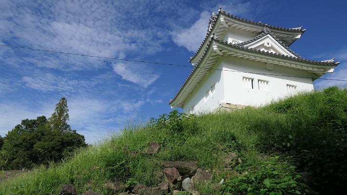
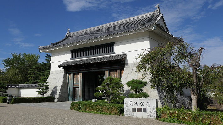
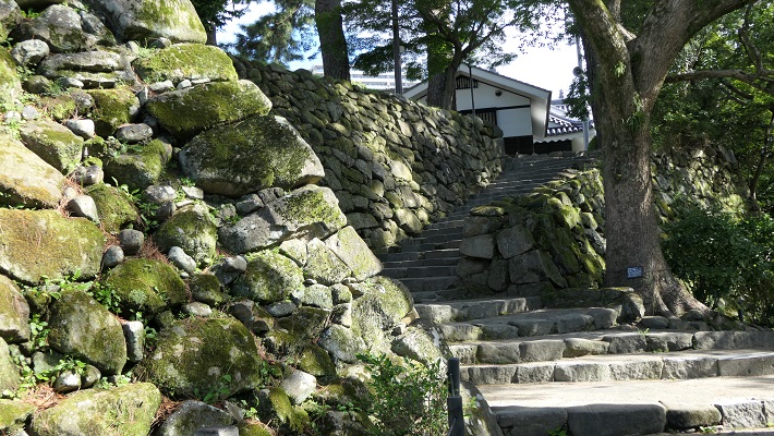
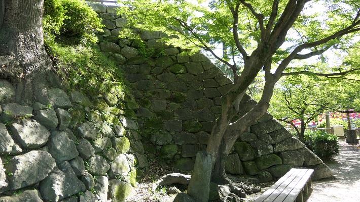
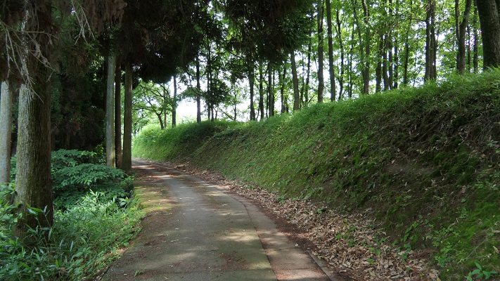
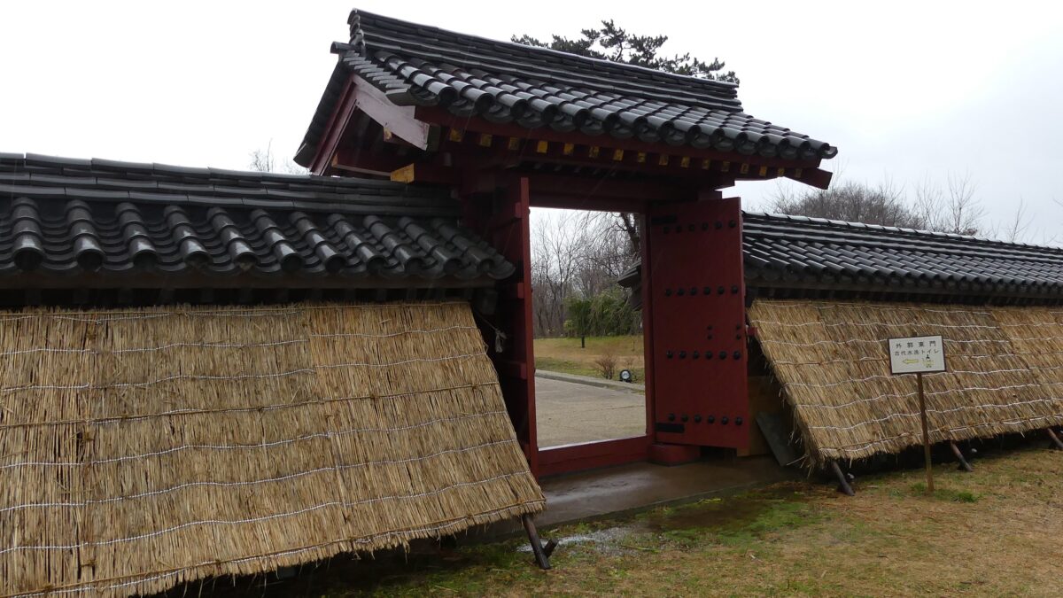
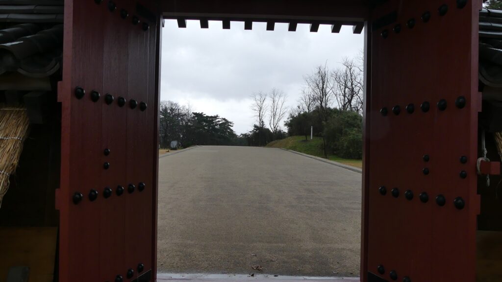
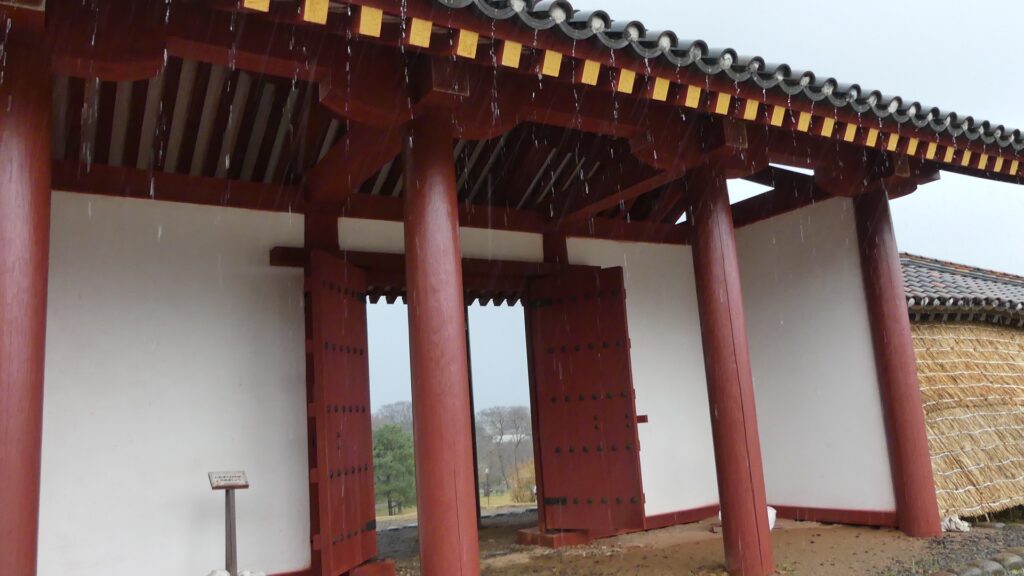
外郭東門~Eastern Gate of Perimeter

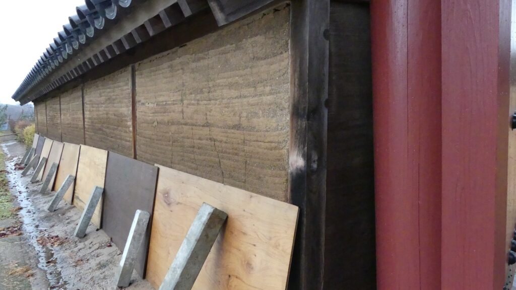
政庁跡からは、12mの幅がある「東大路」という城内道路を歩いて行くことができます。この道路は270m続き、屋根付きの築地塀とともに復元された外郭東門にたどり着きます。この塀は、長さが50mあり、発掘後の研究により外郭の一部として復元されました。双方とも近年元来の工法で、城の初期の状態を想定して作られました。また、塀部分は版築という多層の土を押し固める方法が用いられています。
You can walk on the restored 12m wide inner road called “Higashi-oji” from the government office ruins. This road goes on for 270m, then you will reach the restored eastern gate of the perimeter with the roofed mud walls. These walls, which are about 50m long, are part of the restored perimeter based on the study after excavation. The gate and walls were built in the original way recently, assuming the first appearance of the castle. The walls are also made using a method called Rammed Earth, which refers to compressing many layers of earth.

城内道路~The inner road
復元された外郭東門~The restored Perimeter Eastern Gate
版築で作られた塀、政庁部分より~The wall made of Rammed Earth from the part of the Government Office

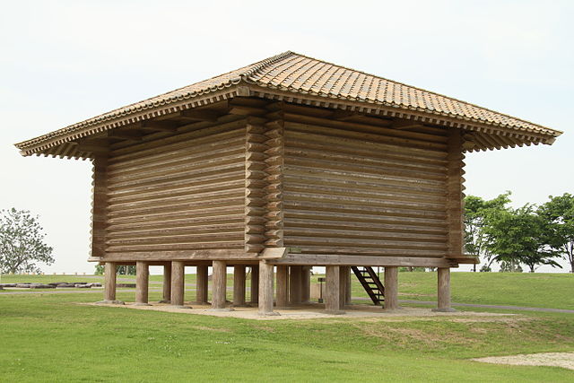
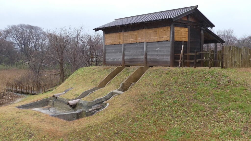
古代水洗トイレ~Ancient flush toilet

この城で最も面白い見物の一つに復元された古代水洗トイレがあります。元からあること自体稀ですが、復元されることも稀です。その上に、もう一つ興味ある事実が遺跡から見つかりました。遺跡からの遺物の中に、豚を食べる人から出る寄生虫の卵があったのです。日本の当時の人たちは豚を食べませんでした。そのため、そのトイレを使った人は外国から、恐らくは渤海か中国から来たに違いないのです。この事実は、古書に書いてあるのと同じように、秋田城と外国との関係を証明しているのです。
One of the most interesting attractions of this castle ruins is the restored ancient flush toilet. The original one was rare, and the restored one is also rare. Moreover, one more interesting fact was found at the ruins. The relics from the ruins include eggs of the parasite which lived in a man who ate pork. Japanese people at that time didn’t eat pork, so the man who used the toilet must have come from a foreign country, probably Bohai or China. The fact proved the relationship between Akita Castle and foreign countries while old documents say the same thing.

復元された水洗トイレ~The restored flush toilet
排出口~The outlet

その後~Later History

中世になって、人々は秋田城のことをまだ覚えていましたが、どこにあったかは誰もわからなくなりました。江戸時代に有名な旅行家の菅江真澄が秋田にしばらく滞在して、辺りを歩き回り、どこに城があったか推測しました。最初の国による近代的調査は1924年に行われ、城の土塁が発見されました。いくつかの調査により、城の場所が特定され、1939年に城跡は国の史跡に指定されました。発掘は1959年以降行われています。更には遺跡が宅地として開発されていたため、行政側も土地の買い上げを始め、歴史公園として整備しました。そのおかげで、私たちは公園で復元された施設を見学できるのです。
In the Middle Ages, people still remembered Akita Castle, but no one was sure where it had been. In the Edo Period, a famous traveler, Masumi Sugae stayed in Akita for a while, walked around the area, and speculated where the castle was. The first modern national research was done in 1924, which discovered the earthen walls for the castle. After the place of the castle had been confirmed by several researches, the ruins were designated as a National Historic Site in 1939. Excavations have been done since 1959. In addition to developing the ruins as a residential area, the officials also started intensive purchase of land to develop them as a historical park. That’s why we can see the developed park with restored items.

1970年代の城周辺の航空写真、宅地化が進んでいました~The aerial photo of the area around the castle in the 1970s, it was becoming a residential area

私の感想~My Impression

私は以前、秋田には、日本の他地域とは違う、アジア大陸の人々に近いDNAを持っている人もいると聞いたことがあります。この話がちょうど秋田城と外国とが関係した説に図らずも一致したことになります。また、この城跡では、日本の歴史の一端を学んだり、見たりするのにいい機会を得られると思います。
I have once heard that some people around Akita may have different DNA from that of other areas in Japan, but similar to people in the Asian continent. I was fascinated as it coincided with the theory of a relationship between Akita Castle and foreign countries. I also think that the ruins of the castle can offer us a good opportunity to learn and see part of Japanese history.

高清水公園にある復元された古代池~The restored Ancient Pond (licensed by 掬茶 via Wikimedia Commons)

ここに行くには~How to get There

車で行く場合は、秋田自動車道の秋田北ICから約15分かかります。秋田城跡歴史資料館脇に駐車場があります。
電車の場合は、JR秋田駅から将軍野線か寺内経由土崎線のバスに乗り、秋田城跡歴史資料館前バス停で降りてください。
If you want to go there by car, it takes about 15 minutes from the Akita-kita IC on Akita Expressway. There is a parking lot beside Akita City History Museum of Akita Fort Ruins.
When using train, take the bus on Shogunno Line or Tsuchizaki Line via Terauchi from JR Akita Station, and take off at the Akitajo-ato-rekishi-shiryokan-mae bus stop.

リンク、参考情報~Links and References

秋田城跡歴史資料館、秋田市(Akita City Official Website)
・「日本の城改訂版第128号」デアゴスティーニジャパン(Japanese Book)
・「蝦夷と城柵の時代」熊谷公男編、吉川弘文館(Japanese Book)

45.Okazaki Castle~岡崎城

この城は徳川家康の生誕地として知られていますが、実際にはもう少し複雑なのです。
This castle is considered to be the birthplace of Ieyasu Tokugawa was born, but actually the story is more complicated.

立地と歴史~Location and History

三河ではよくある立地~Typical location in Mikawa

岡崎城は元々、矢作川と乙川の合流地点にある、龍頭山と呼ばれる小山の上にありました。この城は三河国(現在の愛知県東部に該当)に属してしました。この国においてはよく見られる戦略的立地です。
Okasaki Castle was originally located on a hill called Ryutozan, at the meeting point of the Yahagi River and Oto River. The castle belonged to Mikawa Province (what is now the eastern part of Aichi Pref.). It had s typical strategic location in the province.

城周辺の地図~The map around the castle

城の最初の姿~Its first appearance

15世紀の中頃に西郷稠頼が最初にこの城を築いたと言われています。本丸にある堀の一つが彼の法名を取って「清海」堀と呼ばれています。その後、松平氏がこの城を支配していました。その子孫、徳川家康が更に城を拡張します。その当時の城がどうだったか定かでありませんが、いくつかの曲輪があり、石垣や天守はなかったと思われます。歴史家は、今に残る持仏堂曲輪の形が、その当時の城の特徴を残していると言います。
It is said that Tsuguyori Saigo first built the castle in the middle of the the 15th Century. One of the moats still carries his Buddhist name. It’s called “Seikai” moat of the Main Enclosure or “Honmaru”. After that, the Matsudaira clan took control over the castle. Their descendant Ieyasu Tokugawa improve it. We don’t know exactly what the castle looked like back then, but it seemed to have just a couple of enclosures, no stone walls, and no Main Tower or “Tenshu”. Historians say the shape of the Jibutsu-do enclosure shows the features of the castle at that time.

清海堀~Seikai moat
持仏堂曲輪~Jibutsu-do enclosure

城の完成~The completion of the castle

豊臣氏に仕えた田中吉政が1590年に関東地方に移っていった徳川氏に代わって城に入ってきました。彼は、初代の天守を築き、石垣で取り囲み、外郭を巡らした城下町を作り、城を近代化しました。1600年に家康が天下を取った後は、城は江戸時代を通して譜代大名によって所有されました。本田氏は16世紀中頃までに、天守を置き替え、城の周りの石垣を完成させました。
Yoshimasa Tanaka who served the Toyotomi clan was governing the castle in 1590, instead of Tokugawa who had been transferred to Kanto Region. He modernized the castle by building the first Main Tower or “Tenshu”, surrounding it with stone walls, and making the castle town with an outline. After Ieyasu got the power in 1600, the castle was owned by hereditary feudal lords all through the Edo Period. The Honda clan replaced the Tenshu, and completed the stone walls around the castle by the middle of the 16 century.

現在の復興天守~The present reconstructed Tenshu
三州岡崎城図、江戸時代~The illustration of Okazawaki Castle in Mikawa Province(出典:国立国会図書館)

維持するのは大変~It was hard to maintain

城を統治した大名たちの領地や石高は大きくなかったのですが、幕府創始者である家康ゆかりの城として維持する必要がありました。更には川の氾濫や地震の被害も受けながら、城と周辺地の修繕、改修に努めました。2015年、乙川に沿った400mもの長さの石垣が発見されました。この石垣を築いた理由の一つは洪水を防ぐためだったようです。
Several clans that governed the castle didn’t have large territories and earnings, but they had to maintain it as the founder Ieyasu’s home. They also suffered from river floods as well as earthquakes. They struggled to repair and improve the castle and the area around. In 2015, 400m-long stone walls were discovered along the Oto River. One of the reasons for building them was to prevent floods.

過去の岡崎城のミニチュアモデル~The miniature model of Okazaki Castle in the past(岡崎城内博物館より)
乙川と発見された石垣~Oto River and the stone walls alongside it

その後~Later History

日本最初の「公園」~The first “Park” in Japan

明治維新後、岡崎城は廃城となり、その全ての建物は撤去されました。城跡はその後すぐの1874年に岡崎「公園」となりました。20世紀の初め、有名な造園家である本田静六と、当時岡崎市長であった小瀧喜七郎は、木を植え、図書館や病院などの公共施設を建設し、公園を整備しました。
After the Meiji Restoration, Okazaki Castle was abandoned, and all of their buildings were demolished. The ruins were soon turned into a park called Okazaki “Park” in 1874. In the early 20th century, Seroku Honda, a famous garden designer, and Kishichiro Odaki, the mayor of Okazaki City at that time, improved the park by planting trees, and building public facilities such as a library, and a hospital.

「公園」碑~The monument of “Park”
公園にある小瀧喜七郎の銅像~The statue of Kishichiro Odaki in the park

城の建物の再建~Rebuilding of castle buildings

第二次世界大戦後、公園は歴史公園としても注目されました。城の中心の石垣を伴った基礎部分はよく残っていたためです。1959年、元からあった天守台の上に天守が復興されました。元の天守の詳細は不明でしたが、建築家の城戸久が古写真を参考にして設計しました。戦後日本復興のシンボルの一つと言われています。最近、大手門や東隅櫓なども伝統的建築物として再建されてます。
After World War II, the park was also featured as a historical park, since the foundation with stone walls in the center of the castle still remained. In 1959, the Tenshu was reconstructed on the original Tenshu base. The details of the original Tenshu were uncertain, but Hisashi Kido, an architect, designed it based on old photographs. It is said to be one of the symbols for the reconstruction of Japan. More traditional buildings were recently restored like the Main Entrance Gate “Ote-mon” and the East Corner Turret “Higashi-Sumi Yagura”.

復興天守~The reconstructed Tenshu
再建された東隅櫓~The rebult East Corner Turret

最近の動向~The recent movement

更に最近では、岡崎市は公園を、徳川幕府の創始者、徳川家康の生誕地として位置づけようとしてます。恐らくこれは、観光振興や市のシンボルとするためなのでしょう。市は更に城の建物を復元しようとしていますが、歴史家は植物が育つことで石垣が痛んだり、城としての景観が損なわれると指摘しています。困ったことですが、どう解決するのか見ていきたいと思います。
In more recent years, Okazaki City has been trying to identify the park as the place where Ieayasu Tokugawa, the founder of the Tokugawa Shogunate was born. That’s probably done for tourism and in order to make it a symbol of the city. The city plans to restore more castle buildings, but historians say that growing plants are damaging the stone walls and landscape for the castle. Removing some plants is essential for conserving the ruins of the castle. That’s troubling. I am yet to see how they will solve this problem in the future.

徳川家康肖像画、加納探幽筆、大阪城天守閣蔵~The Portrait of Ieyasu Tokugawa, attributed to Tanyu Kano, owned by Osaka Castle Museum(licensed under Public Domain via Wikimedia Commons)
公園は木々に覆われています~The park is covered with trees

特徴~Features

城エリアに入る~Entering the castle area

城周辺の地図~The map around the castle

東岡崎駅から来られる場合は、乙川の川縁から城の遠景が目に入ってきます。そこには、2015年に発見された長い石垣が川岸に沿っています。
If you come from Higashi-Okazaki Station, you can see the view of the castle ruins from the riverside of the Oto River. There are long stone walls along the riverside which were discovered in2015.

岡崎城の遠景~A dintant view of Okazaki Castle

最初に到着するのは菅生曲輪で、丘の上の城の中心部分も見えます。
You will first reach the Sugo enclosure where you can also see the center of the castle on the hill.

菅生曲輪~Sugo enclosure

復元された大手門に行くには、東曲輪に沿って掘られた道を進みます。この道はかつては堀の底でした。
To reach the restored Ote-mon Gate, go through the road cut along the Higashi enclosure. The road was once used as the bottom of the moat.

ここは堀の底でした~This is where the bottome of the moat was

大手門は岡崎公園の入り口でもあります。門を過ぎると、花壇がある近代公園となった二の丸に入っていきます。
The gate is also the entrance of Okazaki Park. After passing the gate, the Ninomaru enclosure can be seen as a modern park with a flower garden.

再建された大手門~The rebuilt Ote-mon Gate
二の丸にある花時計~The flower clock at Ninomaru(taken by tkworks from photoAC)

本丸エリア~The Honmaru area

本丸の地図~The map of Honmaru

更に本丸の方に進むと、清海堀の前の持仏堂曲輪が見えます。この曲輪は明らかにその丸い形が突き出た格好になっています。空堀により囲まれています。これらは古い時代の徳川の城の特徴であり、家康の時代まで遡る可能性があります。
Going further to the Main Enclosure or “Honmaru”, you can see the Jibutsu-do enclosure in front of the Seikai moat. The enclosure clearly stick out due to its round shaped. It is surrounded with earthen walls. They are the features of the older Tokugawa castle’s defense system that could date back to the Ieyasu Era.

持仏堂曲輪の外側~The outside of Jibutsu-do enclosure
持仏堂曲輪の内側~The inside of Jibutsu-do enclosure

本丸へは大手口、埋門口、風呂谷門口の3つのルートがあります。石垣が残っており、恐らく田中または本田時代に築かれたものです。過去には門や櫓によって厳重に守られていました。
There are three routes to Honmaru, the Ote route, the Uzumi-mon Gate route, and the Furotani-mon Gate route. Their stone walls still remain and they were probably built in the Tanaka and Honda Era. The routes must have been strictly protected by gates and turrets in the past.

大手口~The Ote route
埋門口~The Uzumi-mon Gate route
風呂谷門口~The Furotani-mon Gate route

復興天守は実際にはビル建築であり、歴史博物館としても使われていますが、天守台の石垣は田中氏によって積み上げられました。
The reconstructed Tenshu is actually a modern building which is also used as a historical museum, but the stone walls for its base were originally built by the Tanaka clan.

復興天守とオリジナルの石垣~The reconstructed Tenshu and the original stone walls

家康の史跡~Ieyasu’s landmarks

更には、徳川家康にまつわる史跡としては、家康の銅像や家康公産湯の井戸があります。
In addition, there are landmarks related to Ieyasu Tokugawa such as his statues and the well which was used for his first bath.

公園にある徳川家康の銅像~The statue of Ieyasu Tokugawa
家康公産湯の井戸~The well which was used for Ieyasu’s first bath

私の感想~My Impression

岡崎城の城跡には過去の遺産が染み渡っています。岡崎公園は城の主要の曲輪があった場所に作られました。外郭を含む他の曲輪は既に市街地に変わってしまっています。城の研究や発掘が進めば、新しい発見もあるでしょう。そういったニュースを聞くのが楽しみです。
The ruins of Okazaki Castle are steeped in along legacy. Okazaki Park is built on the spot of the primary enclosures of the castle. Other enclosures including the outline were already turned into the city area. As the studies and the excavation for the castle increase, new discoveries will come. I’m looking forward to hearing about them.

本丸の風呂谷門口近くの古い石垣~The old stone walls near Furotani-mon Gate route at Honmaru

ここに行くには~How to get There

名鉄線東岡崎駅から歩いて約15分です。
東京から東岡崎駅まで:
東海道新幹線に乗り、豊橋駅で名鉄名古屋本線に乗り換えてください。
名古屋から東岡崎駅まで:
名鉄名古屋駅から名古屋本線に乗ってください。
車で行く場合:東名高速道路岡崎ICから約3kmです。公園に駐車場があります。
It takes about 15 minutes From Meitetsu Higashi-Okazaki station to get there on foot.
From Tokyo to Higashi-Okazaki st.:
Take the Tokaido Shinkansen superexpress to Toyohashi station, and transfer for Meitetsu Nagoya line.
From Nagoya to Higashi-Okazaki st.:
Take the train on Meitetsu Nagoya line at Meitetsu-Nagoya station.
If you want to go there by car: It is about 3 km away from the Okazaki IC on Tomei Expressway. The park offer a parking lot.

リンク、参考情報~Links and References

岡崎公園、岡崎市公式観光サイトOkazaki Park
・「三河岡崎城/愛知中世城郭研究会」戒光祥出版(Japanese Book)
・「よみがえる日本の城3」学研(Japanese Book)

189.鞠智城~Kikuchi Castle

It was mysterious, but its achievement took root.
この城は不思議な存在でしたが、その成果は地域に根付きました。

外郭から見た復元された鼓楼~The view of the restored drum tower from the outline

立地と歴史~Location and History

鞠智城は西日本における古代山城の一つです。663年の朝鮮での白村江の戦いの後、朝廷によって築かれました。日本は百済国を助けようとしたのですが、唐と新羅の連合軍に敗れてしまったのです。天智天皇は連合軍の日本への侵攻を恐れ、山城の建設を命じ、それは百済からの難民の力を借りて行われました。そのため、これらの城は「朝鮮式山城」とも呼ばれています。
Kikuchi Castle was one of ancient mountain castles in western Japan. It was built by the Imperial Court after the Battle of Baekgang, Korea in 663. Japan tried to help Baekje, but was beaten by the ally of Tang and Silla. Emperor Tenchi was scared of invasion by the alley, so he ordered to build these castles with the help from the refugees from Baekje. That’s why these castles are also called “Korean style mountain castles”.

白村江の戦いの図~The map about the Battle of Baekgang(licensed by Samhanin via Wikimedia Commons)

鞠智城は、九州地方で記録されている5つの山城のうちの一つです。その他は、大野城、水城、基肄城、金田城です。これらの城は侵攻があった場合に想定される進路に沿って置かれました。しかしながら、鞠智城については少し変なのです。大野城が近くにある大宰府政庁からは60kmも離れていて、もう一つの想定攻撃路である有明湾からも30km離れていました。この城は補給基地であったとか、やはり有明での攻撃に備えたものだという人もいます。ある歴史家は、百済からの難民の収容施設だったのではないかと言っています。なぜならこの周辺地域は、百済との貿易や文化面で関わりがあったからです。事実、この遺跡の貯水池跡から百済観音像が発見されました。加えて、この場所は他の古代山城と比べて低い位置にあり、居住にも適していました。
Kikuchi Castle was one of the five recorded ones in Kyushu region. The others were Ono, Mizuki, Kii, and Kaneda. They had their locations on the way or alongside of expected routes for the invasion. However Kikuchi was a little strange. It was about 60 km away from the Dazaifu government, near Ono Castle, and nearly 30 km from Ariake Bay, another possible attack route. Some speculate it could have been a supply base or preparation for an attack on Ariake. A historian says that the castle could nave been an accommodation for refugees from Baekje, because the area around the castle had been related to Baekje’s in trading and culture. Indeed, a Baekje Buddha statue was excavated from the ruins of the water reservoir. In addition, this site is lower than other ancient mountains castles that made it livable for people.

九州地方の5つの記録された古代山城の位置~The location of five recorded ancient mountain castles in Kyushu region

その後侵攻の危機は去ったのですが、この城は10世紀まで約200年に渡って使われました。この城の歴史の後半においては、軍事拠点、政庁、それに倉庫として使われたようなのです。城の周辺地域は肥沃になり、貿易でも繁栄しました。城が廃城となって約300年後、菊池氏が日本の武士団の頭領となり、侵攻してきた蒙古軍と戦いました。
Despite the crisis of the invasion being resolved, the castle was used for about 200 years until the10th century. In the later stages of its life, it seemed to be an army base, government office, and storage. The area around the castle became fertile and prosperous with trading. About 300 years after the castle was abandoned, the Kikuchi clan fought with the Mongolian Invasion as the leader of Japanese warriors.

菊池武房、「蒙古襲来絵詞」より~Takefusa Kikuchi from “The picture scrolls of the Mongol invasion attempts against Japan”(licensed under Public Domain via Wikimedia Commons)

特徴~Features

近世の城が持つイメージとは違い、この城の主な構造物は、外周が3.5kmに及ぶ外郭部分です。そこには4つの門があり、その間には版築による土塁が続いていました。
Unlike the image of early modern age castles, the main structure of the castle is outlined with a perimeter about 3.5 km long. It had four gates and walls between them were made from rammed earth.

城周辺の地図~The normal map around the castle

外郭土塁の一部~Part of the earthen walls on the oitline

外郭沿いの歩道は現在トレッキングコースになっています。門跡を一つ一つたどっていくことで、城がどのくらいの大きさだったのかがわかります。
The path along the outline is now used for trekking. You can see the ruins of the gates one by one, and feel how large the castle was.

歩道は外郭の土塁に沿っています~The path goes alongside the earthen walls on the outline

駐車場から一番近いのは深迫門で、通用門として使われたとみられます。
The nearest one from the parking lot is Fukasako Gate which could have been used as the side entrance.

深迫門跡~The ruins of Fukasako Gate

次に現れるのは堀切門で、ここが正門だったようです。
The next comes Horikiri Gate which could have been the main entrance.

堀切門跡~The ruins of Horikiri Gate

池の尾門というもう一つの門跡まで見て回ることができます。
外郭の内側には、恐らく鼓楼として使われたであろう三層の塔があり、最近発掘の成果により復元されました。この塔は平面が八角形でした。これは百済から取り入れた様式であり、古代日本ではとても珍しいものです。
You can go ane see another ruins of gate called Ikenoo Gate.
Inside of the outline, the three-layer tower, probably used as the drum tower, has been restored recently with the success of excavation. This tower is octagonal which came from the Baekje style, making it very unique to ancient Japan.

復元された鼓楼~The restored drum tower

兵舎や倉庫といった別種の建物も復元されています。
Other types of buildings such as barracks and warehouses have also been restored.

復元された兵舎~The restored barrack(licensed by 小池隆 via Wikimedea Commons)
復元された倉庫~The restored warehouse(licensed by 小池隆 via Wikimedea Commons)

その後~Later Life

10世紀に廃城となった後、城跡は畠となりました。それもこの地域の繁栄を表しているのかもしれません。この地域が最初に遺跡として調査されたのは1937年のことでした。1967年から2010年に渡っては32回も発掘が行われました。それ以来、研究者はシンポジウムを開催し、この城についての議論を深めています。城跡は歴史公園「鞠智城」として整備されており、鼓楼などの建物が復元されています。
After being abandoned in the 10th century, the ruins of the castle were turned into a farm. That might have shown the prosperity of this area. This area was first researched as ruins in 1937. It was excavated 32times between 1967 and 2010. Since then, while researchers have held symposiums and debated issues with the castle, the ruins has been developed as a historical park called “Kikuchi Castle”. Several buildings such as the drum tower have been restored.

1970年代の城跡周辺の航空写真~The aeriel photo of the area around the castle ruins in the 1970s

最近の城跡周辺の航空写真~The recent aerial photo around the castle ruins

今でもまだ畠が少し残っています~Few farm still remains now

私の感想~My Impression

この城跡は西側に面しているため、晴れた日の夕方には美しい夕日を見ることができます。それは絶好の写真スポットでもあります。私としては、公園の中央にある復元建物を見るだけではなく、歩道に沿った門の跡も見て回っていただきたいです。もっとこの城のことが理解できるでしょう。できたら岡山県の鬼ノ城のように門の一つでも復元されたらと思います。そうすれば世界中から観光客を呼び寄せることも可能かもしれません。
As the ruins face the west direction, you can see the beautiful sunset on a sunny evening. It can also be a good photo spot. I recommend visiting the restored buildings at the center of the park as well as the ruins of the castle’s gate ruins along the sidewalk to know more about the castle. I hope a gate might someday be restored, like Ki-no-Jo in Okayama Prefecture. That way, the castle may attract many people from around the world.

復元された鬼ノ城の西門~The restored Western Gate of Ki-no-Jo

ここに行くには~How to get There

ここに行くには車がお勧めです。九州自動車道植木ICから約20分、熊本空港から約40分かかります。歴史公園に駐車場があります。
I recommend using a car to get there. It takes about 20 minutes from the Ueki IC on Kyushu Expressway, or about 40minutes from Kumamoto Airport. The park offers a parking lot.

リンク、参考情報~Links and References

歴史公園鞠智城・温故創生館(Only Japanese?)
・「古代山城「くくちのき(鞠智城)」九州王朝再興の夢舞台」松見正宣著、文芸社(Japanese Book)
・「古代山城 鞠智城を考える―2009年東京シンポジウムの記録」笹山晴生監修、山川出版社(Japanese Book)